
Leicester topographic map
Interactive map
Click on the map to display elevation.
About this map
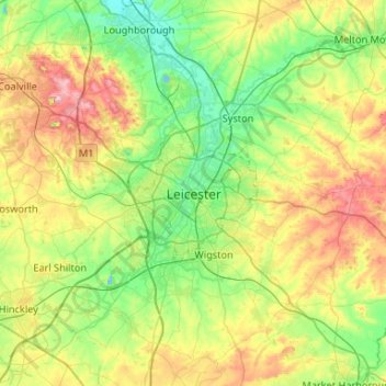
Name: Leicester topographic map, elevation, terrain.
Location: Leicester, Leicestershire, England, LE1 5YA, United Kingdom (52.47620 -1.29320 52.79620 -0.97320)
Average elevation: 109 m
Minimum elevation: 33 m
Maximum elevation: 269 m
Other topographic maps
Click on a map to view its topography, its elevation and its terrain.
Loughborough
United Kingdom > England > Leicestershire > Charnwood
Loughborough, Charnwood, Leicestershire, England, LE11 5BJ, United Kingdom
Average elevation: 61 m
Market Harborough
United Kingdom > England > Leicestershire > Harborough
Market Harborough, Harborough, Leicestershire, England, LE16 7PA, United Kingdom
Average elevation: 106 m
Melton Mowbray
United Kingdom > England > Leicestershire > Melton
Melton Mowbray, Melton, Leicestershire, England, LE13 0PU, United Kingdom
Average elevation: 103 m
Normanton Le Heath
United Kingdom > England > Leicestershire > North West Leicestershire
Normanton Le Heath, North West Leicestershire, Leicestershire, England, United Kingdom
Average elevation: 123 m
Thurmaston
United Kingdom > England > Leicestershire > Charnwood
Thurmaston, Charnwood, Leicestershire, England, United Kingdom
Average elevation: 62 m
Bagworth
United Kingdom > England > Leicestershire > Hinckley and Bosworth
Bagworth, Hinckley and Bosworth, Leicestershire, England, LE67 1BX, United Kingdom
Average elevation: 151 m
Claybrooke Magna
United Kingdom > England > Leicestershire > Harborough
Claybrooke Magna, Harborough, Leicestershire, England, LE17 5DU, United Kingdom
Average elevation: 110 m
Shawell
United Kingdom > England > Leicestershire
Shawell, Leicestershire, England, United Kingdom
Average elevation: 127 m
Scraptoft
United Kingdom > England > Leicestershire > Harborough
Scraptoft, Harborough, Leicestershire, England, LE7 9TE, United Kingdom
Average elevation: 103 m
Drayton
United Kingdom > England > Leicestershire > Harborough
Drayton, Harborough, Leicestershire, England, LE16 8RG, United Kingdom
Average elevation: 82 m
New Lubbesthorpe
United Kingdom > England > Leicestershire > Leicester Forest East
New Lubbesthorpe, Lubbesthorpe, Leicester Forest East, Blaby, Leicestershire, England, LE19 4DA, United Kingdom
Average elevation: 95 m
Croft
United Kingdom > England > Leicestershire
Croft, Blaby, Leicestershire, England, LE9 3HF, United Kingdom
Average elevation: 77 m
Brooksby
United Kingdom > England > Leicestershire > Melton > Rotherby
Brooksby, Hoby with Rotherby, Rotherby, Melton, Leicestershire, England, LE14 2LE, United Kingdom
Average elevation: 76 m
Osgathorpe
United Kingdom > England > Leicestershire > North West Leicestershire
Osgathorpe, North West Leicestershire, Leicestershire, England, United Kingdom
Average elevation: 96 m
Thornton
United Kingdom > England > Leicestershire > Hinckley and Bosworth
Thornton, Hinckley and Bosworth, Leicestershire, England, LE67 1AF, United Kingdom
Average elevation: 146 m
Hinckley
United Kingdom > England > Leicestershire > Hinckley and Bosworth
Hinckley, Hinckley and Bosworth, Leicestershire, England, LE10 1NR, United Kingdom
Average elevation: 105 m
Cropston
United Kingdom > England > Leicestershire > Charnwood
Cropston, Charnwood, Leicestershire, England, LE7 7GE, United Kingdom
Average elevation: 83 m
Narborough
United Kingdom > England > Leicestershire
Narborough, Blaby, Leicestershire, England, United Kingdom
Average elevation: 78 m
Ulverscroft
United Kingdom > England > Leicestershire > Charnwood
Ulverscroft, Charnwood, Leicestershire, England, United Kingdom
Average elevation: 187 m
Charnwood Water
United Kingdom > England > Leicestershire > Charnwood > Woodthorpe
Charnwood Water, Woodthorpe, Charnwood, Leicestershire, England, United Kingdom
Average elevation: 47 m
Ab Kettleby
United Kingdom > England > Leicestershire > Melton
Ab Kettleby, Melton, Leicestershire, England, United Kingdom
Average elevation: 126 m
Pickwell
United Kingdom > England > Leicestershire > Melton
Pickwell, Melton, Leicestershire, England, LE14 2PL, United Kingdom
Average elevation: 168 m
Willoughby Waterleys
United Kingdom > England > Leicestershire > Harborough
Willoughby Waterleys, Harborough, Leicestershire, England, LE8 6UD, United Kingdom
Average elevation: 106 m
Newtown Linford
United Kingdom > England > Leicestershire > Charnwood
Newtown Linford, Charnwood, Leicestershire, England, United Kingdom
Average elevation: 115 m
Gilmorton
United Kingdom > England > Leicestershire > Harborough
Gilmorton, Harborough, Leicestershire, England, United Kingdom
Average elevation: 136 m
Lubbesthorpe
United Kingdom > England > Leicestershire > Braunstone Town
Lubbesthorpe, Braunstone Town, Blaby, Leicestershire, England, United Kingdom
Average elevation: 83 m
Kegworth
United Kingdom > England > Leicestershire > North West Leicestershire
Kegworth, North West Leicestershire, Leicestershire, England, DE74 2EE, United Kingdom
Average elevation: 47 m
Ashby-de-la-Zouch
United Kingdom > England > Leicestershire > North West Leicestershire
Ashby-de-la-Zouch, North West Leicestershire, Leicestershire, England, United Kingdom
Average elevation: 132 m
Lount
United Kingdom > England > Leicestershire > North West Leicestershire
Lount, North West Leicestershire, Leicestershire, England, LE65 1SN, United Kingdom
Average elevation: 118 m
King's Norton
United Kingdom > England > Leicestershire > Harborough
King's Norton, Harborough, Leicestershire, England, LE7 9BF, United Kingdom
Average elevation: 147 m
Market Bosworth Country Park
United Kingdom > England > Leicestershire > Hinckley and Bosworth > Market Bosworth
Market Bosworth Country Park, Market Bosworth, Hinckley and Bosworth, Leicestershire, England, United Kingdom
Average elevation: 119 m
Illston on the Hill
United Kingdom > England > Leicestershire > Harborough
Illston on the Hill, Harborough, Leicestershire, England, LE7 9ET, United Kingdom
Average elevation: 157 m
Shangton
United Kingdom > England > Leicestershire > Harborough
Shangton, Harborough, Leicestershire, England, LE8 0PG, United Kingdom
Average elevation: 127 m
Kelham Bridge Nature Reserve
United Kingdom > England > Leicestershire > North West Leicestershire > Ravenstone
Kelham Bridge Nature Reserve, Melbourne Road, Hugglescote and Donington le Heath, Ravenstone, North West Leicestershire, Leicestershire, England, LE67 2AN, United Kingdom
Average elevation: 139 m
Goadby
United Kingdom > England > Leicestershire > Harborough
Goadby, Harborough, Leicestershire, England, LE7 9EX, United Kingdom
Average elevation: 148 m
South Croxton
United Kingdom > England > Leicestershire > Charnwood
South Croxton, Charnwood, Leicestershire, England, LE7 3RL, United Kingdom
Average elevation: 110 m
Tugby
United Kingdom > England > Leicestershire > Harborough
Tugby, Harborough, Leicestershire, England, LE7 9WF, United Kingdom
Average elevation: 158 m
Rolleston
United Kingdom > England > Leicestershire > Harborough
Rolleston, Harborough, Leicestershire, England, LE7 9EN, United Kingdom
Average elevation: 166 m
Burton Overy
United Kingdom > England > Leicestershire > Harborough
Burton Overy, Harborough, Leicestershire, England, LE8 9DD, United Kingdom
Average elevation: 130 m
Belvoir Castle
United Kingdom > England > Leicestershire > Melton > Belvoir
Belvoir Castle, Woolsthorpe Road, Belvoir, Melton, Leicestershire, England, NG32 1PH, United Kingdom
Average elevation: 82 m
Lea Wood
United Kingdom > England > Leicestershire > Charnwood > Newtown Linford
Lea Wood, Ulverscroft, Newtown Linford, Charnwood, Leicestershire, England, United Kingdom
Average elevation: 170 m
Conservation Area
United Kingdom > England > Leicestershire > Charnwood
Conservation Area, Pig Path, Beacon Cottage Farm, Woodhouse, Charnwood, Leicestershire, England, LE12 8TE, United Kingdom
Average elevation: 168 m
Willesley Woods
United Kingdom > England > Leicestershire > North West Leicestershire > Ashby-de-la-Zouch > Willesley
Willesley Woods, Willesley Wood Side, Ashby-de-la-Zouch, Willesley, North West Leicestershire, Leicestershire, England, LE65 2UP, United Kingdom
Average elevation: 108 m
Moat Hill Spinney
United Kingdom > England > Leicestershire > Charnwood > Cotes
Moat Hill Spinney, Cotes, Charnwood, Leicestershire, England, United Kingdom
Average elevation: 50 m
Coalville
United Kingdom > England > Leicestershire > North West Leicestershire
Coalville, North West Leicestershire, Leicestershire, England, LE67 3DW, United Kingdom
Average elevation: 149 m
Thornton Reservoir
United Kingdom > England > Leicestershire > Hinckley and Bosworth > Thornton
Thornton Reservoir, Bagworth & Thornton, Thornton, Hinckley and Bosworth, Leicestershire, England, United Kingdom
Average elevation: 139 m
Earl Shilton
United Kingdom > England > Leicestershire
Earl Shilton, Leicestershire, England, United Kingdom
Average elevation: 101 m
Kilby Bridge
United Kingdom > England > Leicestershire > Oadby and Wigston > Wigston
Kilby Bridge, Wigston, Oadby and Wigston, Leicestershire, England, LE18 3TF, United Kingdom
Average elevation: 89 m
Merry Lees
United Kingdom > England > Leicestershire > Hinckley and Bosworth > Botcheston
Merry Lees, Bagworth & Thornton, Botcheston, Hinckley and Bosworth, Leicestershire, England, LE67 1AP, United Kingdom
Average elevation: 126 m
Nailstone
United Kingdom > England > Leicestershire > Hinckley and Bosworth
Nailstone, Hinckley and Bosworth, Leicestershire, England, CV13 0QB, United Kingdom
Average elevation: 132 m