Geolocate

National Park Galichica topographic map

Interactive map

Click on the map to display elevation.

About this map

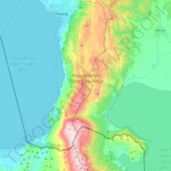
Name: National Park Galichica topographic map, elevation, terrain.

Location: National Park Galichica, Southwestern Region, North Macedonia (40.86557 20.73238 41.13789 20.99436)

Average elevation: 999 m

Minimum elevation: 683 m

Maximum elevation: 2,280 m

Other topographic maps

Click on a map to view its topography, its elevation and its terrain.

Vevchani

North Macedonia > Southwestern Region

Average elevation: 1,177 m

Ohrid

North Macedonia > Southwestern Region

Ohrid is located in the south-western part of North Macedonia, on the shore of Lake Ohrid, at an elevation of 695 meters above sea level.

Average elevation: 786 m

Burinec

North Macedonia > Southwestern Region

Average elevation: 1,153 m

Ohrid

North Macedonia > Southwestern Region > Ohrid

Ohrid is located in the south-western part of North Macedonia, on the shore of Lake Ohrid, at an elevation of 695 meters above sea level.

Average elevation: 963 m

Racha

North Macedonia > Southwestern Region > Racha

Average elevation: 838 m

Debar

North Macedonia > Southwestern Region

Average elevation: 782 m

Jablanica

North Macedonia > Southwestern Region > Jablanica

Average elevation: 1,231 m

Debar

North Macedonia > Southwestern Region > Debar > Debar

Average elevation: 725 m