
Garton on the Wolds topographic map
Interactive map
Click on the map to display elevation.
About this map
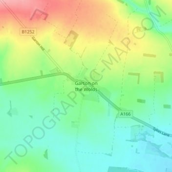
Name: Garton on the Wolds topographic map, elevation, terrain.
Average elevation: 58 m
Minimum elevation: 20 m
Maximum elevation: 127 m
Routes: East Riding of Yorkshire GPS tracks, routes, trails, hikes
Other topographic maps
Click on a map to view its topography, its elevation and its terrain.
Malton Lane Plantation
United Kingdom > England > East Riding of Yorkshire > Bugthorpe
Average elevation: 54 m
Stamford Bridge
United Kingdom > England > East Riding of Yorkshire > Stamford Bridge
Average elevation: 16 m