
Make a donation
Gear up for your next adventure:
As an Amazon Associate, this site earns from qualifying purchases at no extra cost to you.
Newington topographic map
Click on the map to display elevation.
Make a donation
Gear up for your next adventure:
As an Amazon Associate, this site earns from qualifying purchases at no extra cost to you.
Newington
According to the United States Census Bureau, the town has a total area of 12.4 square miles (32.0 km2), of which 8.1 square miles (21.0 km2) are land and 4.2 square miles (11.0 km2) are water, comprising 34.5% of the town. The highest elevation in Newington is 130 feet (40 m) above sea level, near Newington Cemetery in the center of town.
Make a donation
Gear up for your next adventure:
As an Amazon Associate, this site earns from qualifying purchases at no extra cost to you.
About this map
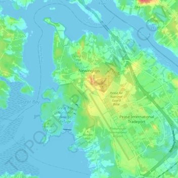
Name: Newington topographic map, elevation, terrain.
Average elevation: 10 m
Minimum elevation: -7 m
Maximum elevation: 47 m
Make a donation
Gear up for your next adventure:
As an Amazon Associate, this site earns from qualifying purchases at no extra cost to you.
Other topographic maps
Click on a map to view its topography, its elevation and its terrain.
Hampton River
United States > New Hampshire > Rockingham County > Hampton Falls
Average elevation: 1 m
South Beacon Shoal
United States > New Hampshire > Rockingham County > Portsmouth
Average elevation: 4 m
Make a donation
Gear up for your next adventure:
As an Amazon Associate, this site earns from qualifying purchases at no extra cost to you.
Make a donation
Gear up for your next adventure:
As an Amazon Associate, this site earns from qualifying purchases at no extra cost to you.
Make a donation
Gear up for your next adventure:
As an Amazon Associate, this site earns from qualifying purchases at no extra cost to you.
Rye Beach Village District
United States > New Hampshire > Rockingham County > Rye Beach Village District
Average elevation: 7 m
Salem Depot
United States > New Hampshire > Rockingham County > Salem > Salem Depot
Average elevation: 50 m
Make a donation
Gear up for your next adventure:
As an Amazon Associate, this site earns from qualifying purchases at no extra cost to you.