
Make a donation
Gear up for your next adventure:
As an Amazon Associate, this site earns from qualifying purchases at no extra cost to you.
Mogok topographic map
Click on the map to display elevation.
Make a donation
Gear up for your next adventure:
As an Amazon Associate, this site earns from qualifying purchases at no extra cost to you.
Mogok
At 1,170 metres (3,840 ft) in elevation, the city has a fairly temperate climate year-round, and is home to Bamar, Shan, Lisu, Palaung, and Karen ethnic groups, as well as Chinese, Indians and Gurkhas. The city is composed of two towns, Mogok and Kyat Pyin. Mogok is four miles long and two miles wide. It is situated in a valley surrounded by a large number of mountains. Kyatpyin lies about 7 miles (11 km) southwest of Mogok. Tourists that travel to this area need a special authorization and a guide person.[6]
Make a donation
Gear up for your next adventure:
As an Amazon Associate, this site earns from qualifying purchases at no extra cost to you.
About this map
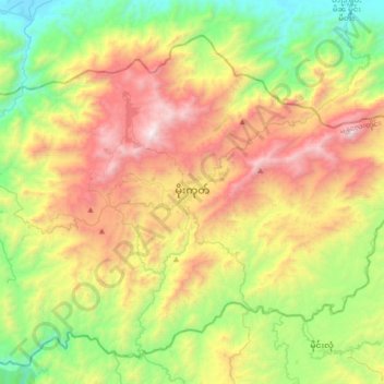
Name: Mogok topographic map, elevation, terrain.
Average elevation: 993 m
Minimum elevation: 173 m
Maximum elevation: 2,227 m
Make a donation
Gear up for your next adventure:
As an Amazon Associate, this site earns from qualifying purchases at no extra cost to you.
Other topographic maps
Click on a map to view its topography, its elevation and its terrain.
Make a donation
Gear up for your next adventure:
As an Amazon Associate, this site earns from qualifying purchases at no extra cost to you.
Make a donation
Gear up for your next adventure:
As an Amazon Associate, this site earns from qualifying purchases at no extra cost to you.
Make a donation
Gear up for your next adventure:
As an Amazon Associate, this site earns from qualifying purchases at no extra cost to you.
Make a donation
Gear up for your next adventure:
As an Amazon Associate, this site earns from qualifying purchases at no extra cost to you.
Make a donation
Gear up for your next adventure:
As an Amazon Associate, this site earns from qualifying purchases at no extra cost to you.
Thabeikkyin Township
Myanmar > Mandalay > Pyin Oo Lwin District > Thabeikkyin Township
Average elevation: 316 m
Ayeyarwaddy International School
Myanmar > Mandalay > Mandalay District > Mandalay > Chanayethazan Township
Average elevation: 78 m
Make a donation
Gear up for your next adventure:
As an Amazon Associate, this site earns from qualifying purchases at no extra cost to you.