
El Serrat topographic map
Interactive map
Click on the map to display elevation.
El Serrat
El Serrat (Catalan pronunciation: [əl səˈrat]) is a mountain village in the parish of Ordino, Andorra. It is at an elevation of 1,540 metres (5,100 ft). It is a popular destination for skiers.[2]
About this map
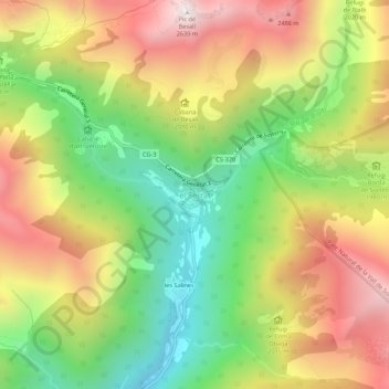
Name: El Serrat topographic map, elevation, terrain.
Location: El Serrat, Ordino, AD300, Andorra (42.59958 1.51890 42.63958 1.55890)
Average elevation: 1,995 m
Minimum elevation: 1,427 m
Maximum elevation: 2,626 m
Other topographic maps
Click on a map to view its topography, its elevation and its terrain.
Andorra la Vella
The principal industry is tourism, and the country also earns foreign income from being a tax haven. It is at an elevation of 1,023 m (3,356 ft), and is the highest capital city in Europe. The city shares a border with Spain.
Average elevation: 1,584 m
Andorra la Vella
The principal industry is tourism, and the country also earns foreign income from being a tax haven. It is at an elevation of 1,023 m (3,356 ft), and is the highest capital city in Europe. The city shares a border with Spain.
Average elevation: 1,584 m
Andorra la Vella
The principal industry is tourism, although the country also earns foreign income from being a tax haven. Furniture and brandies are local products. Being at an elevation of 1,023 m (3,356 ft), it is the highest capital city in Europe and a popular ski resort.
Average elevation: 1,270 m
Encamp
Radio Andorra operated a transmitter at Lake Engolasters in Encamp from 7 August 1939 until 9 April 1981. The antenna still exists at an elevation of 1,600 metres (5,200 ft) (coordinates: 42°31′18″N 1°34′10″E / 42.52167°N 1.56944°E / 42.52167; 1.56944 (Radio Andorra transmitter)).
Average elevation: 1,992 m
La Massana
Coma Pedrosa in the north-west of the parish is the highest point in the Principality of Andorra at 2,942 metres (9,652 ft), and has panoramic views of the Pyrenees. The mountain is also the site of the Coma Pedrosa Nature Reserve. It is covered by heavy snowfalls in winter, and usually retains some snow cover…
Average elevation: 1,877 m