
Make a donation
Gear up for your next adventure:
As an Amazon Associate, this site earns from qualifying purchases at no extra cost to you.
Kinale ward topographic map
Click on the map to display elevation.
Make a donation
Gear up for your next adventure:
As an Amazon Associate, this site earns from qualifying purchases at no extra cost to you.
About this map
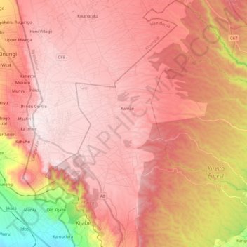
Name: Kinale ward topographic map, elevation, terrain.
Location: Kinale ward, Lari, Kiambu, Central Kenya, Kenya (-0.96732 36.55541 -0.75823 36.74695)
Average elevation: 2,458 m
Minimum elevation: 1,839 m
Maximum elevation: 2,747 m
Make a donation
Gear up for your next adventure:
As an Amazon Associate, this site earns from qualifying purchases at no extra cost to you.
Other topographic maps
Click on a map to view its topography, its elevation and its terrain.
Kijabe
Kenya > Kiambu > Lari > Kinale ward
It stands on the edge of the Great Rift Valley at an altitude of 2200m, some 50 kilometres north-west of Nairobi. Kijabe is located in the sub-county of Lari, Kiambu County. Kijabe has a population 2,026 in 2019. Kijabe has a railway station along the Uganda Railway. The town is located between Limuru and…
Average elevation: 2,311 m
Make a donation
Gear up for your next adventure:
As an Amazon Associate, this site earns from qualifying purchases at no extra cost to you.