
Kijabe topographic map
Click on the map to display elevation.
Kijabe
It stands on the edge of the Great Rift Valley at an altitude of 2200m, some 50 kilometres north-west of Nairobi. Kijabe is located in the sub-county of Lari, Kiambu County. Kijabe has a population 2,026 in 2019. Kijabe has a railway station along the Uganda Railway. The town is located between Limuru and Naivasha.
About this map
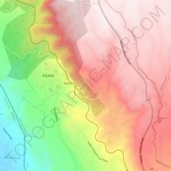
Name: Kijabe topographic map, elevation, terrain.
Location: Kijabe, Kinale ward, Lari, Kiambu, Central Kenya, Kenya (-0.97669 36.58903 -0.92268 36.62528)
Average elevation: 2,311 m
Minimum elevation: 1,836 m
Maximum elevation: 2,616 m