
Morristown topographic map
Interactive map
Click on the map to display elevation.
About this map
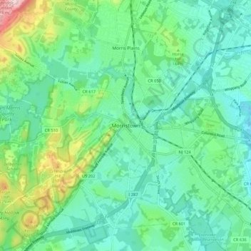
Name: Morristown topographic map, elevation, terrain.
Location: Morristown, Morris County, New Jersey, 07960, United States (40.75704 -74.52099 40.83704 -74.44099)
Average elevation: 123 m
Minimum elevation: 60 m
Maximum elevation: 316 m
Other topographic maps
Click on a map to view its topography, its elevation and its terrain.
Parsippany
United States > New Jersey > Morris County > Parsippany-Troy Hills > Lake Hiawatha
Average elevation: 86 m
Brookside
United States > New Jersey > Morris County > Mendham Township > Brookside
Average elevation: 173 m
Parsippany
United States > New Jersey > Morris County > Parsippany-Troy Hills > Lake Hiawatha
Average elevation: 86 m
Landing
United States > New Jersey > Morris County > Roxbury Township > Port Morris
Average elevation: 297 m
Chatham
United States > New Jersey > Morris County
The Passaic River, which rises at Millington Gorge in Long Hill Township and defines the Great Swamp, flows north along the eastern boundary of Chatham. A good crossing location, identified by Native Americans to early European settlers, figured significantly in the colonial history of the community. Fairmount…
Average elevation: 76 m
Parsippany
United States > New Jersey > Morris County > Parsippany-Troy Hills > Lake Hiawatha
Average elevation: 86 m
Chatham
United States > New Jersey > Morris County
The Passaic River, which rises at Millington Gorge in Long Hill Township and defines the Great Swamp, flows north along the eastern boundary of Chatham. A good crossing location, identified by Native Americans to early European settlers, figured significantly in the colonial history of the community. Fairmount…
Average elevation: 76 m
Kinnelon
United States > New Jersey > Morris County
The highest mountain in Kinnelon is Kitty Ann Mountain. Located in Smoke Rise, the mountain offers views of northern New Jersey at an elevation of 1,140 feet (350 m) from the Smoke Rise Tower.
Average elevation: 196 m
Madison
United States > New Jersey > Morris County
Madison's historic railroad station was funded by the community, which passed an ordinance authorizing $159,000 for railroad improvement bonds. The result, with the cooperation of the D.L. & W.R.R. in the planning, was completed in 1916. The tracks were elevated through the downtown so that no established…
Average elevation: 88 m
Long Valley
United States > New Jersey > Morris County > Washington Township > Long Valley
Average elevation: 235 m
Kinnelon
United States > New Jersey > Morris County
The highest mountain in Kinnelon is Kitty Ann Mountain. Located in Smoke Rise, the mountain offers views of northern New Jersey at an elevation of 1,140 feet (350 m) from the Smoke Rise Tower.
Average elevation: 196 m
Boonton Reservoir
United States > New Jersey > Morris County > Parsippany-Troy Hills
Average elevation: 102 m
Rockaway River Wildlife Management Area
United States > New Jersey > Morris County > Jefferson Township
Average elevation: 276 m
Mine Hill
United States > New Jersey > Morris County
According to the United States Census Bureau, the township had a total area of 3.00 square miles (7.76 km2), including 2.94 square miles (7.61 km2) of land and 0.06 square miles (0.15 km2) of water (1.93%). The township is at an elevation of 863 feet (263 m) above sea level for the administrative center.
Average elevation: 245 m
Mooney Mountain Park
United States > New Jersey > Morris County > Roxbury Township
Average elevation: 326 m
Chatham
United States > New Jersey > Morris County
The Passaic River, which rises at Millington Gorge in Long Hill Township and defines the Great Swamp, flows north along the eastern boundary of Chatham. A good crossing location, identified by Native Americans to early European settlers, figured significantly in the colonial history of the community. Fairmount…
Average elevation: 76 m
Chatham Township
United States > New Jersey > Morris County > Chatham Township
Average elevation: 86 m
Roxbury Township
United States > New Jersey > Morris County > Roxbury Township
Average elevation: 268 m
Madison
United States > New Jersey > Morris County
Madison's historic railroad station was funded by the community which passed an ordinance authorizing $159,000 for railroad improvement bonds. The result with the cooperation of the D.L. & W.R.R. in the planning was completed in 1916. The tracks were elevated through the downtown and no established roadways…
Average elevation: 88 m