Geolocate

Sta. Barbara topographic map

Click on the map to display elevation.

About this map

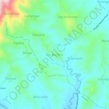
Name: Sta. Barbara topographic map, elevation, terrain.

Location: Sta. Barbara, Iloilo, Western Visayas, 5029, Philippines (10.68096 122.21992 10.72096 122.25992)

Average elevation: 107 m

Minimum elevation: 33 m

Maximum elevation: 385 m

Other topographic maps

Click on a map to view its topography, its elevation and its terrain.

Zarraga

Philippines > Iloilo

Average elevation: 10 m

Oton

Philippines > Iloilo > Oton

Average elevation: 11 m

Estancia

Philippines > Iloilo > Estancia

Average elevation: 11 m

Leganes

Philippines > Iloilo

Average elevation: 9 m

Pavia

Philippines > Iloilo

Average elevation: 15 m

Miagao

Philippines > Iloilo

Average elevation: 97 m

Gear up for your next adventure:

🔋Rechargeable Batteries - Eco-friendly power for headlamps and older GPS units
🧤Waterproof Overmitts - Extreme weather protection for hikers and mountaineers
👕Merino Base Layers - Natural temperature regulation for cold weather hiking and camping
🌦️Portable Weather Meters - Handheld tools for monitoring weather conditions
🔋Lithium AA Batteries - Long-lasting power that performs well in cold mountain weather

As an Amazon Associate, this site earns from qualifying purchases at no extra cost to you.