
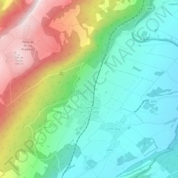
Les Geneveys-sur-Coffrane topographic map
Interactive map
Click on the map to display elevation.
About this map
Name: Les Geneveys-sur-Coffrane topographic map, elevation, terrain.
Location: Les Geneveys-sur-Coffrane, Val-de-Ruz, Neuchâtel, 2206, Suisse (47.00374 6.80918 47.03501 6.86904)
Average elevation: 975 m
Minimum elevation: 751 m
Maximum elevation: 1,416 m
Au nord-ouest du village culmine le mont Racine, à 1 439 mètres d'altitude.
Other topographic maps
Click on a map to view its topography, its elevation and its terrain.
Savagnier
Suisse > Neuchâtel > Val-de-Ruz
Savagnier, Val-de-Ruz, Neuchâtel, 2065, Suisse
Average elevation: 860 m