
Clanfield topographic map
Click on the map to display elevation.
About this map
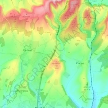
Name: Clanfield topographic map, elevation, terrain.
Location: Clanfield, East Hampshire, Hampshire, England, United Kingdom (50.92852 -1.03801 50.96038 -0.94029)
Average elevation: 126 m
Minimum elevation: 46 m
Maximum elevation: 252 m
Hampshire trails, hiking, mountain biking, running and outdoor activities
Other topographic maps
Click on a map to view its topography, its elevation and its terrain.
Liphook
United Kingdom > England > Hampshire > East Hampshire
In Samuel Lewis's 1831 Topographical Dictionary of England, he referred to Liphook as a hamlet in the parish of Bramshott.
Average elevation: 121 m
Rowland's Copse, Red Hill
United Kingdom > England > Hampshire > East Hampshire > Rowlands Castle
Average elevation: 42 m
Cold Ash Hill
United Kingdom > England > Hampshire > East Hampshire > Bramshott
Average elevation: 126 m
Hartley Mauditt
United Kingdom > England > Hampshire > East Hampshire > Hartley Mauditt
Average elevation: 123 m
Comp
United Kingdom > England > Hampshire > East Hampshire > Upper Farringdon
Average elevation: 126 m
Bramshott Common
United Kingdom > England > Hampshire > East Hampshire > Bramshott
Average elevation: 148 m
Gilbert Street
United Kingdom > England > Hampshire > East Hampshire > Ropley
Average elevation: 151 m
Havant Thicket
United Kingdom > England > Hampshire > East Hampshire > Rowlands Castle
Average elevation: 48 m
Ludshott Common
United Kingdom > England > Hampshire > East Hampshire > Bramshott
Average elevation: 162 m
Ditcham Woods.
United Kingdom > England > Hampshire > East Hampshire > Buriton
Average elevation: 136 m
Merryfield
United Kingdom > England > Hampshire > East Hampshire > West Tisted
Average elevation: 164 m
Neatham
United Kingdom > England > Hampshire > East Hampshire > Alton > Holybourne
Average elevation: 122 m
Froxfield Green
United Kingdom > England > Hampshire > East Hampshire > High Cross
Average elevation: 177 m