
Hasan Dağı topographic map
Click on the map to display elevation.
Hasan Dağı
The volcano has two summits, the 3,069 metres (10,069 ft) high eastern Small Hasan Dagi/Küçük Hasandağ and the 3,253 metres (10,673 ft) high Big Hasan Dagi/Büyük Hasandağ; both are located within a caldera and consist of lava domes and lava flows. Big Hasan Dagi has two nested craters with an 800 metres (2,600 ft) wide and 200 metres (660 ft) high inner cone that is the source of a lava flow. Fossil rock glaciers are found on the volcano. The volcano as a whole rises almost 1 kilometre (0.62 mi) around the surrounding terrain and covers an area of 760 square kilometres (290 sq mi) with 354 cubic kilometres (85 cu mi) of rocks. The terrain of Mount Hasan is formed by phreatomagmatic breccias, ignimbrites, lahar deposits, lava domes, lava flows and pyroclastic flow deposits. The pyroclastic flow deposits occur in the form of fans or valley flows, when they were channelled by topography. The northern flanks also feature two debris avalanche deposits with hummocky surfaces. The volcanics of Mount Hasan have been subdivided into a "hot flow" unit, a "Mt. Hasan ashes" unit and into a lava unit.
About this map
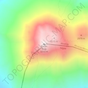
Name: Hasan Dağı topographic map, elevation, terrain.
Average elevation: 2,707 m
Minimum elevation: 2,228 m
Maximum elevation: 3,265 m