Geolocate

El Asintal topographic map

Interactive map

Click on the map to display elevation.

About this map

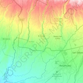
Name: El Asintal topographic map, elevation, terrain.

Location: El Asintal, Retalhuleu, Guatemala (14.50107 -91.80154 14.66731 -91.71381)

Average elevation: 359 m

Minimum elevation: 77 m

Maximum elevation: 893 m

Other topographic maps

Click on a map to view its topography, its elevation and its terrain.

Municipio de Retalhuleu

Guatemala > Retalhuleu

Municipio de Retalhuleu, Retalhuleu, Guatemala

Average elevation: 139 m

San Andrés Villa Seca

Guatemala > Retalhuleu > San Andrés Villa Seca

San Andrés Villa Seca, Retalhuleu, Guatemala

Average elevation: 462 m

Champerico

Guatemala > Retalhuleu

Champerico, Retalhuleu, Guatemala

Average elevation: 18 m

Tulate

Guatemala > Retalhuleu > Tulate

Tulate, San Andrés Villa Seca, Retalhuleu, Guatemala

Average elevation: 5 m

El Hato

Guatemala > Retalhuleu > Municipio de Retalhuleu

El Hato, Municipio de Retalhuleu, Retalhuleu, Guatemala

Average elevation: 75 m