
Make a donation
Gear up for your next adventure:
As an Amazon Associate, this site earns from qualifying purchases at no extra cost to you.
Basque topographic map
Click on the map to display elevation.
Make a donation
Gear up for your next adventure:
As an Amazon Associate, this site earns from qualifying purchases at no extra cost to you.
About this map
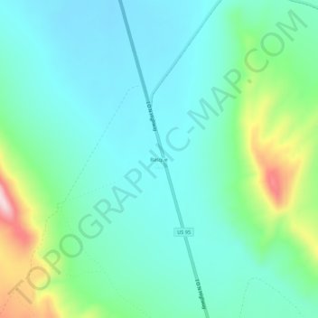
Name: Basque topographic map, elevation, terrain.
Location: Basque, Malheur County, Oregon, United States (42.39144 -117.88281 42.43144 -117.84281)
Average elevation: 1,411 m
Minimum elevation: 1,339 m
Maximum elevation: 1,651 m
Make a donation
Gear up for your next adventure:
As an Amazon Associate, this site earns from qualifying purchases at no extra cost to you.
Other topographic maps
Click on a map to view its topography, its elevation and its terrain.
Vale
United States > Oregon > Malheur County
According to the United States Census Bureau, the city has a total area of 1.14 square miles (2.95 km2), all of it land. The city has an elevation of 2,244 feet (684 m) above sea level.
Average elevation: 710 m
Make a donation
Gear up for your next adventure:
As an Amazon Associate, this site earns from qualifying purchases at no extra cost to you.