
Stallikon topographic map
Interactive map
Click on the map to display elevation.
About this map
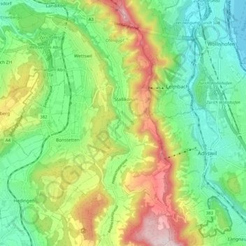
Name: Stallikon topographic map, elevation, terrain.
Location: Stallikon, Bezirk Affoltern, Zürich, 8143, Schweiz (47.28561 8.46904 47.35472 8.51011)
Average elevation: 577 m
Minimum elevation: 402 m
Maximum elevation: 887 m
Other topographic maps
Click on a map to view its topography, its elevation and its terrain.
Wettswil am Albis
Schweiz > Zürich > Bezirk Affoltern
Wettswil am Albis, Bezirk Affoltern, Zürich, 8907, Schweiz
Average elevation: 571 m
Hausen am Albis
Schweiz > Zürich > Bezirk Affoltern > Hausen am Albis
Hausen am Albis, Bezirk Affoltern, Zürich, Schweiz
Average elevation: 636 m
Affoltern am Albis
Schweiz > Zürich > Bezirk Affoltern
Affoltern am Albis, Bezirk Affoltern, Zürich, Schweiz
Average elevation: 549 m