
Make a donation
Gear up for your next adventure:
As an Amazon Associate, this site earns from qualifying purchases at no extra cost to you.
Central Macedonia topographic map
Click on the map to display elevation.
Make a donation
Gear up for your next adventure:
As an Amazon Associate, this site earns from qualifying purchases at no extra cost to you.
About this map
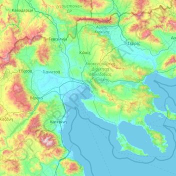
Name: Central Macedonia topographic map, elevation, terrain.
Location: Central Macedonia, Macedonia and Thrace, Greece (39.83097 21.70420 41.40659 24.12707)
Average elevation: 375 m
Minimum elevation: -4 m
Maximum elevation: 2,855 m
Make a donation
Gear up for your next adventure:
As an Amazon Associate, this site earns from qualifying purchases at no extra cost to you.
Other topographic maps
Click on a map to view its topography, its elevation and its terrain.
Athens
Greece > Attica > Regional Unit of Central Athens
Owing to the rain shadow of the Pindus Mountains, annual precipitation of Athens is lower than most other parts of Greece, especially western Greece. As an example, Ioannina receives around 1,300 mm (51 in) per year, and Agrinio around 800 mm (31 in) per year. Daily average highs for July have been measured…
Average elevation: 168 m
Karpenisi
Greece > Central Greece > Regional Unit of Evrytania > Municipal Unit of Karpenisi
Karpenisi (Greek: Καρπενήσι, Greek pronunciation: [karpeˈnisi]) is a town in central Greece. It is the capital of the regional unit of Evrytania. Karpenisi lies within the valley of the river Karpenisiotis (Καρπενησιώτης), a tributary of the Megdovas, in the southern part of the Pindus…
Average elevation: 1,236 m
Make a donation
Gear up for your next adventure:
As an Amazon Associate, this site earns from qualifying purchases at no extra cost to you.
Athens
Greece > Attica > Regional Unit of Central Athens
Owing to the rain shadow of the Pindus Mountains, annual precipitation of Athens is lower than most other parts of Greece, especially western Greece. As an example, Ioannina receives around 1,300 mm (51 in) per year, and Agrinio around 800 mm (31 in) per year. Daily average highs for July have been measured…
Average elevation: 168 m
Archanes
Greece > Region of Crete > Heraklion Regional Unit > Archanes Municipal Unit
Average elevation: 333 m
Stemnitsa
Greece > Peloponnese, Western Greece and the Ionian > Arcadia Regional Unit > Municipal Unit of Trikolonoi
Stemnitsa (Greek: Στεμνίτσα) is a mountain village in the municipal unit of Trikolonoi, Arcadia, Peloponnese, Greece. It was the seat of the former municipality Trikolonoi. Stemnitsa is a traditional settlement and is considered one of the most beautiful villages in Arcadia, due to its picturesque…
Average elevation: 1,166 m
Make a donation
Gear up for your next adventure:
As an Amazon Associate, this site earns from qualifying purchases at no extra cost to you.
Epitalio
Greece > Western Greece > Elis Regional Unit > Municipality of Pyrgos
Average elevation: 24 m
Make a donation
Gear up for your next adventure:
As an Amazon Associate, this site earns from qualifying purchases at no extra cost to you.
Serres
Greece > Macedonia and Thrace > Serres Regional Unit
Serres is one of the administrative and economic centers of Northern Greece. The city is situated in a fertile plain at an elevation of about 70 metres (230 feet), some 24 kilometres (15 miles) northeast of the Strymon river and 69 km (43 mi) north-east of Thessaloniki, respectively. Serres' official municipal…
Average elevation: 317 m
Imera
Greece > Epirus and Western Macedonia > Kozani Regional Unit > Servia Municipal Unit
Average elevation: 418 m
Leontio
Greece > Peloponnese Region > Corinthia Regional Unit > Municipality of Nemea
Average elevation: 456 m
Make a donation
Gear up for your next adventure:
As an Amazon Associate, this site earns from qualifying purchases at no extra cost to you.
Ioannina
Greece > Epirus > Ioannina Regional Unit
Ioannina (Greek: Ιωάννινα Ioánnina [i.oˈa.ni.na] (listen)), often called Yannena (Γιάννενα Yánnena [ˈʝa.ne.na]) within Greece, is the capital and largest city of the Ioannina regional unit and of Epirus, an administrative region in north-western Greece. According to the 2011 census, the…
Average elevation: 724 m
Eleusis
Greece > Attica > Regional Unit of West Attica > Municipal Unit of Elefsina
Average elevation: 30 m
Eretria
Greece > Central Greece > Euboea Regional Unit > Eretria Municipal Unit
Average elevation: 45 m
Make a donation
Gear up for your next adventure:
As an Amazon Associate, this site earns from qualifying purchases at no extra cost to you.
Knossos Palace
Greece > Region of Crete > Heraklion Regional Unit > Heraklion Municipal Unit
The identification of Knossos with the Bronze Age site is supported by the Roman coins that were scattered over the fields surrounding the pre-excavation site, then a large mound named Kephala Hill, elevation 85 m (279 ft) from current sea level. Many of them were inscribed with Knosion or Knos on the obverse…
Average elevation: 151 m
Taygeti
Greece > Peloponnese Region > Laconia Regional Unit > Municipal Unit of Mystras
Average elevation: 806 m
Make a donation
Gear up for your next adventure:
As an Amazon Associate, this site earns from qualifying purchases at no extra cost to you.
Ermioni
Greece > Peloponnese, Western Greece and the Ionian > Argolis Regional Unit > Municipal Unit of Ermioni
Average elevation: 55 m
Mátala
Greece > Region of Crete > Heraklion Regional Unit > Tybakio Municipal Unit
Average elevation: 56 m
Make a donation
Gear up for your next adventure:
As an Amazon Associate, this site earns from qualifying purchases at no extra cost to you.
Vikos–Aoos National Park
Greece > Epirus > Ioannina Regional Unit
The Vikos–Aoös National Park (Greek: Εθνικός Δρυμός Βίκου–Αώου, romanized: Ethnikós Drymós Víkou–Aóou) is a national park in the region of Epirus in northwestern Greece. The park, founded in 1973, is one of ten national parks in mainland Greece and is located 30 kilometres (19…
Average elevation: 1,147 m
Λαγονήσι
Greece > Attica > Regional Unit of East Attica > Kalyvia Thorikou Municipal Unit
Average elevation: 30 m
Make a donation
Gear up for your next adventure:
As an Amazon Associate, this site earns from qualifying purchases at no extra cost to you.
Naoussa
Greece > Macedonia and Thrace > Imathia Regional Unit
Naousa is located in Northwestern Imathia, 22 kilometers north of Veria and 90 kilometers west of Thessaloniki. The city lies on the eastern foothills of Vermio Mountains, one of the biggest mountain ranges in Greece, and west to the plain of Giannitsa. Naousa is today the largest forest-owning municipality in…
Average elevation: 652 m
Athens
Greece > Attica > Regional Unit of Central Athens
The southern section of the Athens metropolitan area (i.e., Elliniko, Athens Riviera) lies in the transitional zone between Mediterranean (Csa) and hot semi-arid climate (BSh), with its port-city of Piraeus being the most extreme example, receiving just 331.9 millimetres (13.07 in) per year. The areas to the…
Average elevation: 168 m
Krathio
Greece > Western Greece > Achaia Regional Unit > Municipal Unit of Akrata
Average elevation: 54 m
Neo Perivoli
Greece > Thessaly > Larisa Regional Unit > Municipal Unit of Kileler
Average elevation: 146 m
Make a donation
Gear up for your next adventure:
As an Amazon Associate, this site earns from qualifying purchases at no extra cost to you.
Alexandreia
Greece > Central Macedonia > Imathia Regional Unit
Alexandreia is a located in the vast plain north of the river Aliakmonas and west of the river Axios, named Kampania or also Roumlouki. Its economy is chiefly based on the agricultural utilization of the surrounding fields. The area around Alexandreia has the greatest production of peaches in Greece and…
Average elevation: 24 m
Kavala
Greece > Macedonia and Thrace > Kavala Regional Unit
On July 16, 2022, Meridian Flight 3032 crashed near the village. The Ukrainian-registered Antonov An-12BK was carrying 11.5 tons of ammunition from Niš to Dhaka when the plane began to lose altitude over the Aegean and turned around, but went down 35 kilometers west of Kavala Airport. All 8 crew members were…
Average elevation: 173 m
Make a donation
Gear up for your next adventure:
As an Amazon Associate, this site earns from qualifying purchases at no extra cost to you.
Meteora
Greece > Thessaly > Trikala Regional Unit > Kastraki
The Monastery of Rousanou is believed to have been constructed, like many of the other monasteries, in the 14th century. The cathedral is believed to have been built in the 16th century and later decorated in 1540. The name Rousanou is believed to come from the first group of monks who settled on the rock from…
Average elevation: 429 m
Hymettus
Greece > Attica > Regional Unit of Central Athens
The highest point of the mountain range is Evzonas (Εύζωνας) with an elevation of 1,026 m (3,366 ft). The 16 km (9.9 mi) length of Hymettus stretches from Athens to the Saronic Gulf. It is 6 to 7 km from east to west. In ancient times, the highest point was known as Megas Hymettos and the southern peaks…
Average elevation: 680 m
Dimitsana
Greece > Peloponnese Region > Arcadia Regional Unit > Municipal Unit of Dimitsana
Dimitsana is built on a mountain slope at an elevation of 950 meters. From its southern side a marvelous view of the Megalopolis plain and Taygetus is provided. Dimitsana is located 53 km east of Pyrgos, 31 km northwest of Tripoli, 23 km northwest of Megalopoli and 17 km northeast of Andritsaina. The village…
Average elevation: 1,025 m
Make a donation
Gear up for your next adventure:
As an Amazon Associate, this site earns from qualifying purchases at no extra cost to you.
Make a donation
Gear up for your next adventure:
As an Amazon Associate, this site earns from qualifying purchases at no extra cost to you.
Patras
Greece > Peloponnese, Western Greece and the Ionian > Achaia Regional Unit
A central feature of the urban geography of Patras is its division into upper and lower sections. This is the result of an interplay between natural geography and human settlement patterns; the lower section of the city (Kato Poli), which includes the 19th-century urban core and the port, is adjacent to the…
Average elevation: 283 m
Argos
Greece > Peloponnese, Western Greece and the Ionian > Argolis Regional Unit
Average elevation: 322 m
Make a donation
Gear up for your next adventure:
As an Amazon Associate, this site earns from qualifying purchases at no extra cost to you.
Nea Makri
Greece > Attica > Regional Unit of East Attica > Nea Makri Municipal Unit
Average elevation: 122 m
Astakos
Greece > Western Greece > Aetolia-Acarnania Regional Unit > Municipal Unit of Astakos
Average elevation: 225 m
Mount Ainos National Park
Greece > Ioanian Islands > Kefallonia Regional Unit > Municipal Unit of Elios-Proni
Average elevation: 501 m
Make a donation
Gear up for your next adventure:
As an Amazon Associate, this site earns from qualifying purchases at no extra cost to you.
Pine
Greece > Western Greece > Aetolia-Acarnania Regional Unit > Municipal Unit of Palairos
Average elevation: 65 m
Περτούλι
Greece > Thessaly > Trikala Regional Unit
Pertouli is a small mountain village within the province of Trikala in Greece and is situated at an altitude of 1,150 metres on the central part of the Pindos mountain range.
Average elevation: 1,358 m
Περτούλι
Greece > Thessaly > Trikala Regional Unit
Pertouli is a small mountain village within the province of Trikala in Greece and is situated at an altitude of 1,150 metres on the central part of the Pindos mountain range.
Average elevation: 1,358 m
Make a donation
Gear up for your next adventure:
As an Amazon Associate, this site earns from qualifying purchases at no extra cost to you.
Συκή
Greece > Thessaly > Regional Unit of Magnesia > Municipal Unit of Afetes
Average elevation: 220 m
Make a donation
Gear up for your next adventure:
As an Amazon Associate, this site earns from qualifying purchases at no extra cost to you.
Malia
Greece > Region of Crete > Heraklion Regional Unit > Malia Municipal Unit
Average elevation: 199 m
Labyrintaki Cave
Greece > Region of Crete > Heraklion Regional Unit > Mires Municipal Unit
Average elevation: 308 m
Make a donation
Gear up for your next adventure:
As an Amazon Associate, this site earns from qualifying purchases at no extra cost to you.
Σέρβια
Greece > Epirus and Western Macedonia > Kozani Regional Unit > Servia Municipal Unit
The Philharmonic band of the town, established in 1928, is run by the "Morphotikos Omilos Servion", which is the main Cultural Society of the town. It organises a wide range of cultural events and supports teaching classes for children and adults in painting, dance, choir, and chess. Hang gliding is prominent…
Average elevation: 565 m
Rapsani
Greece > Thessaly > Larisa Regional Unit > Municipal Unit of Kato Olympos
Rapsani is sited at an altitude of 600 meters. The location of Peneus river at the level of the station Rapsani is a scenic landscape. The town is close (5 km) from a station that bears the same name.
Average elevation: 501 m
Make a donation
Gear up for your next adventure:
As an Amazon Associate, this site earns from qualifying purchases at no extra cost to you.
Pylos
Greece > Peloponnese Region > Messenia Regional Unit
The erection of this fort led to one of the most memorable events in the Peloponnesian War. Thucydides has given a minute account of the topography of the district, which, though clear and consistent with itself, does not coincide, in all points, with the existing locality, Thucydides describes the harbour, of…
Average elevation: 79 m
Ζήρεια
Greece > Peloponnese Region > Corinthia Regional Unit > Municipal Unit of Xylokastro
Average elevation: 1,561 m
Thiva
Greece > Central Greece > Regional Unit of Boeotia > Municipal Unit of Thebes
Thebes is situated in a plain, between Lake Yliki (ancient Hylica) to the north, and the Cithaeron mountains, which divide Boeotia from Attica, to the south. Its elevation is 215 m (705 ft) above mean sea level. It is about 50 km (31 mi) northwest of Athens, and 100 km (62 mi) southeast of Lamia. The A1…
Average elevation: 218 m
Pilion
Greece > Thessaly and Central Greece > Regional Unit of Magnesia > Municipal Unit of Mouresi
The mountain is thickly forested, with both deciduous and perennial forests, mainly of beech, oak, maple and chestnut trees, with olive, apple, pear trees and plane tree groves surrounding places with water. Pelion is considered one of the most beautiful mountains in Greece and is a popular tourist attraction…
Average elevation: 1,239 m
Make a donation
Gear up for your next adventure:
As an Amazon Associate, this site earns from qualifying purchases at no extra cost to you.
Make a donation
Gear up for your next adventure:
As an Amazon Associate, this site earns from qualifying purchases at no extra cost to you.
Στενά Νέστου
Greece > Macedonia and Thrace > Kavala Regional Unit > Paradisos
Average elevation: 449 m
Πρόδρομος
Greece > Thessaly and Central Greece > Regional Unit of Boeotia > Δημοτική Ενότητα Θίσβης
Average elevation: 368 m
Make a donation
Gear up for your next adventure:
As an Amazon Associate, this site earns from qualifying purchases at no extra cost to you.
Athens
Greece > Attica > Regional Unit of Central Athens
The southern section of the Athens metropolitan area (i.e., Elliniko, Athens Riviera) lies in the transitional zone between Mediterranean (Csa) and hot semi-arid climate (BSh), with its port-city of Piraeus being the most extreme example, receiving just 331.9 millimetres (13.07 in) per year. The areas to the…
Average elevation: 168 m
Magouliana
Greece > Peloponnese Region > Arcadia Regional Unit > Municipal Unit of Vytina
Average elevation: 1,176 m
Make a donation
Gear up for your next adventure:
As an Amazon Associate, this site earns from qualifying purchases at no extra cost to you.
Make a donation
Gear up for your next adventure:
As an Amazon Associate, this site earns from qualifying purchases at no extra cost to you.
Makrichori
Greece > Thessaly > Larisa Regional Unit > Municipal Unit of Makrichori
Average elevation: 139 m
Make a donation
Gear up for your next adventure:
As an Amazon Associate, this site earns from qualifying purchases at no extra cost to you.
Tsivili beach
Greece > Ioanian Islands > Zakynthos Regional Unit > Arkadii Municipal Unit
Average elevation: 15 m
Agios Konstantinos
Greece > Northern Aegean > Samos Regional Unit > Municipal Unit of Vathy
Average elevation: 135 m
Vourvourou
Greece > Central Macedonia > Chalkidiki Regional Unit > Sithonia Municipal Unit
Average elevation: 94 m
Make a donation
Gear up for your next adventure:
As an Amazon Associate, this site earns from qualifying purchases at no extra cost to you.