
Cannock Wood topographic map
Interactive map
Click on the map to display elevation.
About this map
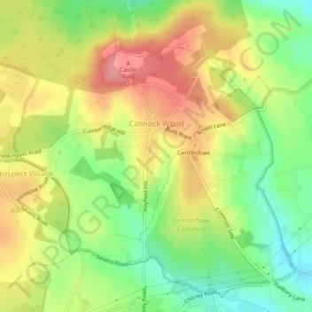
Name: Cannock Wood topographic map, elevation, terrain.
Average elevation: 192 m
Minimum elevation: 140 m
Maximum elevation: 244 m
Other topographic maps
Click on a map to view its topography, its elevation and its terrain.
Hednesford Hills
United Kingdom > England > Staffordshire > Cannock Chase
Hednesford Hills, Cannock Chase, Staffordshire, England, WS12 1BF, United Kingdom
Average elevation: 194 m
Cannock
United Kingdom > England > Staffordshire > Cannock Chase
Cannock, Cannock Chase, Staffordshire, England, WS11 1AW, United Kingdom
Average elevation: 145 m
Brereton
United Kingdom > England > Staffordshire > Cannock Chase
Brereton, Cannock Chase, Staffordshire, England, WS15 1HH, United Kingdom
Average elevation: 106 m
Hednesford
United Kingdom > England > Staffordshire > Cannock Chase
Hednesford, Cannock Chase, Staffordshire, England, United Kingdom
Average elevation: 185 m
Rugeley
United Kingdom > England > Staffordshire > Cannock Chase
Rugeley, Cannock Chase, Staffordshire, England, United Kingdom
Average elevation: 90 m
Norton Canes
United Kingdom > England > Staffordshire > Cannock Chase
Norton Canes, Cannock Chase, Staffordshire, England, WS11 9RE, United Kingdom
Average elevation: 158 m