
Westoning topographic map
Click on the map to display elevation.
About this map
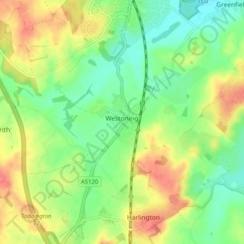
Name: Westoning topographic map, elevation, terrain.
Location: Westoning, Central Bedfordshire, England, United Kingdom (51.96756 -0.53406 51.99557 -0.46365)
Average elevation: 86 m
Minimum elevation: 61 m
Maximum elevation: 116 m
Central Bedfordshire trails, hiking, mountain biking, running and outdoor activities
Other topographic maps
Click on a map to view its topography, its elevation and its terrain.
Dunstable Downs
United Kingdom > England > Central Bedfordshire > Church End
Because of its elevation, Dunstable Downs hosted a station in the shutter telegraph chain which connected the Admiralty in London to its naval ships in the port of Great Yarmouth during the years 1808 to 1814.
Average elevation: 178 m
Lower Caldecote
United Kingdom > England > Central Bedfordshire > Upper Caldecote
Average elevation: 32 m
Edgecote
United Kingdom > England > Central Bedfordshire > Caddington > Aley Green
Average elevation: 168 m
Houghton Hall Park
United Kingdom > England > Central Bedfordshire > Houghton Regis
Average elevation: 134 m
Dog Kennel Down
United Kingdom > England > Central Bedfordshire > Houghton Regis
Average elevation: 138 m
Totternhoe Knolls
United Kingdom > England > Central Bedfordshire > Church End > Lower End
Average elevation: 105 m
Crawley Park
United Kingdom > England > Central Bedfordshire > Aspley Guise > Husborne Crawley
Average elevation: 98 m