
Make a donation
Gear up for your next adventure:
As an Amazon Associate, this site earns from qualifying purchases at no extra cost to you.
Thompson Falls topographic map
Click on the map to display elevation.
Make a donation
Gear up for your next adventure:
As an Amazon Associate, this site earns from qualifying purchases at no extra cost to you.
Thompson Falls
Thompson Falls is located at 47°35′48″N 115°20′37″W / 47.59667°N 115.34361°W / 47.59667; -115.34361 (47.596587, -115.343730) in the Clark Fork Valley at an elevation of 2,419 feet (737 m).
Make a donation
Gear up for your next adventure:
As an Amazon Associate, this site earns from qualifying purchases at no extra cost to you.
About this map
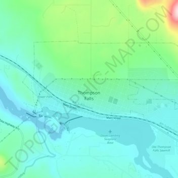
Name: Thompson Falls topographic map, elevation, terrain.
Location: Thompson Falls, Sanders County, Montana, United States (47.58906 -115.36343 47.60768 -115.31243)
Average elevation: 782 m
Minimum elevation: 713 m
Maximum elevation: 1,022 m
Make a donation
Gear up for your next adventure:
As an Amazon Associate, this site earns from qualifying purchases at no extra cost to you.
Other topographic maps
Click on a map to view its topography, its elevation and its terrain.
Make a donation
Gear up for your next adventure:
As an Amazon Associate, this site earns from qualifying purchases at no extra cost to you.