
Make a donation
Gear up for your next adventure:
As an Amazon Associate, this site earns from qualifying purchases at no extra cost to you.
White Pine topographic map
Click on the map to display elevation.
Make a donation
Gear up for your next adventure:
As an Amazon Associate, this site earns from qualifying purchases at no extra cost to you.
About this map
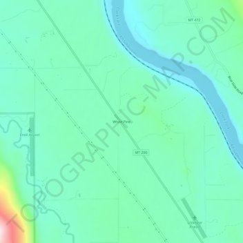
Name: White Pine topographic map, elevation, terrain.
Location: White Pine, Sanders County, Montana, United States (47.72351 -115.50220 47.76351 -115.46220)
Average elevation: 782 m
Minimum elevation: 704 m
Maximum elevation: 1,099 m
Make a donation
Gear up for your next adventure:
As an Amazon Associate, this site earns from qualifying purchases at no extra cost to you.
Other topographic maps
Click on a map to view its topography, its elevation and its terrain.
Paradise
United States > Montana > Sanders County > Paradise
Paradise is located at 47°23′17″N 114°48′3″W / 47.38806°N 114.80083°W / 47.38806; -114.80083 (47.388097, -114.800723), elevation 2,250 feet (690 m). It is at the confluence of the Flathead River and Clark Fork River. Nearby Patrick's Knob reaches 6,775 feet (2,065 m).
Average elevation: 881 m
Thompson Falls
United States > Montana > Sanders County
Thompson Falls is located at 47°35′48″N 115°20′37″W / 47.59667°N 115.34361°W / 47.59667; -115.34361 (47.596587, -115.343730) in the Clark Fork Valley at an elevation of 2,419 feet (737 m).
Average elevation: 782 m
Make a donation
Gear up for your next adventure:
As an Amazon Associate, this site earns from qualifying purchases at no extra cost to you.
Make a donation
Gear up for your next adventure:
As an Amazon Associate, this site earns from qualifying purchases at no extra cost to you.