
Baitadi topographic map
Interactive map
Click on the map to display elevation.
About this map
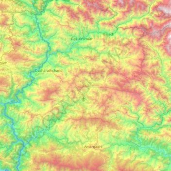
Name: Baitadi topographic map, elevation, terrain.
Location: Baitadi, Sudurpashchim Province, Nepal (29.30868 80.24199 29.70821 80.90862)
Average elevation: 1,529 m
Minimum elevation: 366 m
Maximum elevation: 3,600 m
Other topographic maps
Click on a map to view its topography, its elevation and its terrain.
Darchula District (Nepal)
Nepal > Sudurpashchim Province
The Himalayan region between two rivers Kali River to Seti River calls Gurans Himal. Darchula district falls in the Gurans Himal zone. Api Himal (7,132 metres (23,399 ft)) and Jethi Bahurani (6,850 metres (22,470 ft)) are main mountain peaks of the area. There is a protected area named Api Nampa Conservation…
Average elevation: 3,387 m