
Havasu Falls topographic map
Interactive map
Click on the map to display elevation.
About this map
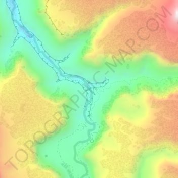
Name: Havasu Falls topographic map, elevation, terrain.
Location: Havasu Falls, Coconino County, Arizona, United States (36.25516 -112.69790 36.25526 -112.69780)
Average elevation: 1,123 m
Minimum elevation: 803 m
Maximum elevation: 1,514 m
Other topographic maps
Click on a map to view its topography, its elevation and its terrain.
Williams
United States > Arizona > Coconino County
Williams is located at 35°14′58″N 112°11′24″W / 35.24944°N 112.19000°W / 35.24944; -112.19000 (35.249369, −112.189872) at 6,800 feet (2,100 m) in elevation. Bill Williams Mountain rises to an elevation of 9,256 feet (2,821 m) just south of Williams. According to the United States Census…
Average elevation: 2,131 m
Flagstaff
United States > Arizona > Coconino County
Flagstaff, the county seat of Coconino County. According to the United States Census Bureau, the city has a total area of 63.9 square miles (165.5 km2), of which only 0.03 square miles (0.08 km2) (0.08%) is water. Flagstaff lies at approximately 7,000 feet (2,130 m) elevation, and is surrounded by the largest…
Average elevation: 2,151 m
Oak Creek Canyon
United States > Arizona > Coconino County
Oak Creek Canyon is about 12 miles (19 km) long, ranging in width from 0.8 to 2.5 miles (1.3 to 4.0 km). The depth of the canyon ranges from 800 to 2,000 feet (240 to 610 m). However, due to the faulting that played a major role in its formation, the west rim of the canyon is 700 feet (210 m) higher than the…
Average elevation: 1,859 m
Sedona
United States > Arizona > Coconino County
Sedona’s interior chaparral has many shrubs and small tree species of Quercus turbinella and Rhus ovata and a large population of Quercus palmeri. The Great Basin woodland has many small to medium trees of Pinus monophylla Var. fallax, Juniperus arizonica, Juniperus deppeana, Juniperus osteosperma, and…
Average elevation: 1,458 m
Sedona
United States > Arizona > Coconino County
Sedona interior chaparral has many shrubs and small tree species of Quercus turbinella and Rhus ovata and a large population of Quercus palmeri. The Great Basin woodland has many small to medium trees of Pinus monophylla Var. fallax, Juniperus arizonica, Juniperus deppeana, Juniperus osteosperma, and Juniperus…
Average elevation: 1,342 m
Walnut Canyon National Monument
United States > Arizona > Coconino County > Flagstaff
Walnut Canyon National Monument (Hopi: Wupatupqa) is a United States National Monument located about 10 mi (16 km) southeast of downtown Flagstaff, Arizona, near Interstate 40. The canyon rim elevation is 6,690 ft (2,040 m); the canyon's floor is 350 ft (110 m) lower. A 0.9 mi (1.4 km) long loop trail descends…
Average elevation: 1,968 m
Page
United States > Arizona > Coconino County
Unlike other cities in the area, Page was founded in 1957 as a housing community for workers and their families during the construction of nearby Glen Canyon Dam on the Colorado River. Its 17-square-mile (44 km2) site was obtained in a land exchange with the Navajo Nation. The city is perched atop Manson Mesa…
Average elevation: 1,225 m
Sedona
United States > Arizona > Coconino County
Sedona interior chaparral has many shrubs and small tree species of Quercus turbinella and Rhus ovata and a large population of Quercus palmeri. The Great Basin woodland has many small to medium trees of Pinus monophylla Var. fallax, Juniperus arizonica, Juniperus deppeana, Juniperus osteosperma, and Juniperus…
Average elevation: 1,342 m
Flagstaff
United States > Arizona > Coconino County
Flagstaff is the county seat of Coconino County. According to the United States Census Bureau, the city has a total area of 63.9 square miles (165.5 km2), of which only 0.03 square miles (0.08 km2) (0.08%) is water. Flagstaff lies at approximately 7,000 feet (2,130 m) elevation, and is surrounded by the…
Average elevation: 2,176 m
Grand Canyon Village
United States > Arizona > Coconino County > Grand Canyon Village
Average elevation: 1,666 m
Flagstaff
United States > Arizona > Coconino County
Flagstaff, the county seat of Coconino County. According to the United States Census Bureau, the city has a total area of 63.9 square miles (165.5 km2), of which only 0.03 square miles (0.08 km2) (0.08%) is water. Flagstaff lies at approximately 7,000 feet (2,130 m) elevation, and is surrounded by the largest…
Average elevation: 2,176 m
Page
United States > Arizona > Coconino County
Unlike other cities in the area, Page was founded in 1957 as a housing community for workers and their families during the construction of nearby Glen Canyon Dam on the Colorado River. Its 17-square-mile (44 km2) site was obtained in a land exchange with the Navajo Nation. The city is perched atop Manson Mesa…
Average elevation: 1,225 m
Bitter Springs
United States > Arizona > Coconino County
The mean elevation is 5,115 feet (1,559 m) above sea level. The US Postal Service ZIP code is 86040.
Average elevation: 1,697 m
Sedona
United States > Arizona > Coconino County
Sedona interior chaparral has many shrubs and small tree species of Quercus turbinella and Rhus ovata and a large population of Quercus palmeri. The Great Basin woodland has many small to medium trees of Pinus monophylla Var. fallax, Juniperus arizonica, Juniperus deppeana, Juniperus osteosperma, and Juniperus…
Average elevation: 1,342 m
Grand Canyon Village
United States > Arizona > Coconino County > Grand Canyon Village
Average elevation: 1,666 m
Williams
United States > Arizona > Coconino County
Williams is located at 35°14′58″N 112°11′24″W / 35.24944°N 112.19000°W / 35.24944; -112.19000 (35.249369, −112.189872) at 6,800 feet (2,100 m) in elevation. Bill Williams Mountain rises to an elevation of 9,256 feet (2,821 m) just south of Williams. According to the United States Census…
Average elevation: 2,131 m
Flagstaff
United States > Arizona > Coconino County
Flagstaff is the county seat of Coconino County. According to the United States Census Bureau, the city has a total area of 63.9 square miles (165.5 km2), of which only 0.03 square miles (0.08 km2) (0.08%) is water. Flagstaff lies at approximately 7,000 feet (2,130 m) elevation, and is surrounded by the…
Average elevation: 2,151 m
Glen Canyon Dam
United States > Arizona > Coconino County
The Bureau of Reclamation favored the Echo Park site over Glen Canyon, because its narrow canyons and high elevation (more than 5,000 feet (1,500 m), as compared to 3,700 feet (1,100 m) at Glen Canyon) would lead to less evaporation. It said that building Echo Park Dam and a "low" Glen Canyon Dam would save…
Average elevation: 1,171 m
Sedona
United States > Arizona > Coconino County
Sedona interior chaparral has many shrubs and small tree species of Quercus turbinella, Rhus ovata, and a large population of Quercus palmeri. The Great Basin woodland has many small to medium trees of Pinus monopylla Var. fallax, Juniperus arizonica, Juniperus deppeana, Juniperus osteosperma, Juniperus…
Average elevation: 1,342 m
Flagstaff
United States > Arizona > Coconino County
Flagstaff is the county seat of Coconino County. According to the United States Census Bureau, the city has a total area of 63.9 square miles (165.5 km2), of which only 0.03 square miles (0.08 km2) (0.08%) is water. Flagstaff lies at approximately 7,000 feet (2,130 m) elevation, and is surrounded by the…
Average elevation: 2,176 m
Williams
United States > Arizona > Coconino County
Bill Williams Mountain rises to an elevation of 9,256 feet (2,821 m) just south of Williams. According to the United States Census Bureau, the city has a total area of 43.8 square miles (113 km2), of which 43.5 square miles (113 km2) is land and 0.3 square miles (0.78 km2), or 0.66%, is water.
Average elevation: 2,131 m
Grand Canyon Village
United States > Arizona > Coconino County > Grand Canyon Village
Average elevation: 1,666 m