
Make a donation
Gear up for your next adventure:
As an Amazon Associate, this site earns from qualifying purchases at no extra cost to you.
Anjouan topographic map
Click on the map to display elevation.
Make a donation
Gear up for your next adventure:
As an Amazon Associate, this site earns from qualifying purchases at no extra cost to you.
Anjouan
Anjouan is part of the Comoros Islands located in the Mozambique Channel. It consists of the eroded remains of a large shield volcano that formed in the Pleistocene epoch. Eruptions from fissure vents spanned in three directions, followed by a long interval of erosion. Renewed volcanism produced a series of lava flows that filled deep valleys and flooded areas along the coast. The island is known for its steep, mountainous terrain and black sand beaches. Mount Ntringui is the highest point in the island of Anjouan with an elevation of 1,595 m (5,233 ft) above sea level. The second most important (and the most populous) city on Anjouan is Domoni. The main strategic area is the airfield at Ouani, with its 1.5 km runway, and the bay with the coastal road from the chief town Mutsamudu in the east out to the city of Sima in the west.
Make a donation
Gear up for your next adventure:
As an Amazon Associate, this site earns from qualifying purchases at no extra cost to you.
About this map
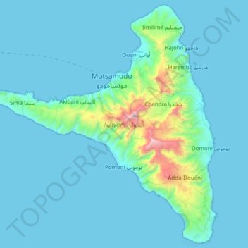
Name: Anjouan topographic map, elevation, terrain.
Location: Anjouan, Comoros (-12.38495 44.20478 -12.06821 44.54064)
Average elevation: 133 m
Minimum elevation: 0 m
Maximum elevation: 1,568 m
Make a donation
Gear up for your next adventure:
As an Amazon Associate, this site earns from qualifying purchases at no extra cost to you.
Other topographic maps
Click on a map to view its topography, its elevation and its terrain.