Geolocate

Kingston upon Thames topographic map

Interactive map

Click on the map to display elevation.

About this map

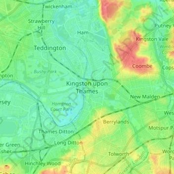
Name: Kingston upon Thames topographic map, elevation, terrain.

Location: Kingston upon Thames, Greater London, England, KT1 1JS, United Kingdom (51.36963 -0.34626 51.44963 -0.26626)

Average elevation: 19 m

Minimum elevation: -2 m

Maximum elevation: 63 m

Routes: England GPS tracks, routes, trails, hikes

Other topographic maps

Click on a map to view its topography, its elevation and its terrain.

London

United Kingdom > England > London

Average elevation: 42 m

Bristol

United Kingdom > England > City of Bristol

Average elevation: 55 m

Birmingham

United Kingdom > England

Birmingham is a snowy city relative to other large UK conurbations, due to its inland location and comparatively high elevation. Between 1961 and 1990 Birmingham Airport averaged 13.0 days of snow lying annually, compared to 5.33 at London Heathrow. Snow showers often pass through the city via the Cheshire gap…

Average elevation: 138 m

Norwich

United Kingdom > England > Norfolk

Average elevation: 28 m

London

United Kingdom > England

Average elevation: 66 m

Cornwall

United Kingdom > England

The interior of the county consists of a roughly east–west spine of infertile and exposed upland, with a series of granite intrusions, such as Bodmin Moor, which contains the highest land within Cornwall. From east to west, and with approximately descending altitude, these are Bodmin Moor, Hensbarrow north…

Average elevation: 55 m

Sheffield

United Kingdom > England

Average elevation: 168 m

Devon

United Kingdom > England

Average elevation: 94 m

Bolton

United Kingdom > England

Average elevation: 151 m

Nottingham

United Kingdom > England > Nottinghamshire

Average elevation: 56 m

Oxfordshire

United Kingdom > England

Average elevation: 113 m

Gloucester

United Kingdom > England > Gloucestershire

Average elevation: 36 m

Borough of Luton

United Kingdom > England

The local climate around Luton is differentiated somewhat from much of South East England due to its position in the Chiltern Hills, meaning it tends to be 1–2 degrees Celsius cooler than the surrounding towns – often flights at Luton airport, lying 160 m (525 ft) above sea level, will be suspended when…

Average elevation: 146 m

City of Bristol

United Kingdom > England

Average elevation: 80 m

Southampton

United Kingdom > England

Average elevation: 22 m

South East England

United Kingdom > England

Near Weybridge are the UK headquarters of Sony with SSP Group (situated in Byfleet) and Procter & Gamble (next door to each other on The Heights Business Park near the former Brooklands racing circuit) with Kia Motors UK and Petroleum Geo-Services UK, and Gallaher Group (cigarettes) is to the north, next to…

Average elevation: 69 m

Somerset

United Kingdom > England

Average elevation: 87 m

Exeter

United Kingdom > England > Devon

Average elevation: 56 m

Eastbourne

United Kingdom > England > East Sussex

Average elevation: 36 m

Leeds

United Kingdom > England

Average elevation: 96 m

Liverpool

United Kingdom > England

Average elevation: 26 m

York

United Kingdom > England > York

Average elevation: 21 m

Brighton

United Kingdom > England > Brighton and Hove

Average elevation: 64 m

North Norfolk

United Kingdom > England > Norfolk

Average elevation: 26 m

Wiltshire

United Kingdom > England

Average elevation: 115 m

Essex

United Kingdom > England

Average elevation: 44 m

Salford

United Kingdom > England

Average elevation: 52 m

Preston

United Kingdom > England > Lancashire

Average elevation: 58 m

Cambridge

United Kingdom > England > Cambridge

The city, like most of the UK, has a maritime climate highly influenced by the Gulf Stream. Located in the driest region of Britain, Cambridge's rainfall averages around 570 mm (22.44 in) per year, around half the national average, with some years occasionally falling into the semi-arid (under 500 mm (19.69…

Average elevation: 18 m

Durham

United Kingdom > England > County Durham

Average elevation: 119 m

Gloucestershire

United Kingdom > England

Average elevation: 99 m

Hampshire

United Kingdom > England

Average elevation: 73 m

Manchester

United Kingdom > England

Average elevation: 66 m

Bath

United Kingdom > England > Bath and North East Somerset

Bath is in the Avon Valley and is surrounded by limestone hills as it is near the southern edge of the Cotswolds, a designated Area of Outstanding Natural Beauty, and the limestone Mendip Hills rise around 7 miles (11 km) south of the city. The hills that surround and make up the city have a maximum altitude…

Average elevation: 100 m

Oxford

United Kingdom > England > Oxfordshire

Average elevation: 81 m

Coventry

United Kingdom > England

Average elevation: 99 m

Reading

United Kingdom > England > West Berkshire > Reading

Mary Russell Mitford lived in Reading for a number of years and then spent the rest of her life just outside the town at Three Mile Cross and Swallowfield. The fictional Belford Regis of her eponymous novel, first published in 1835, is largely based on Reading. Described with topographical accuracy, it is…

Average elevation: 56 m

Plymouth

United Kingdom > England > Devon > Plymouth

The River Plym, which flows off Dartmoor to the north-east, forms a smaller estuary to the east of the city called Cattewater. Plymouth Sound is protected from the sea by the Plymouth Breakwater, in use since 1814. In the Sound is Drake's Island which is seen from Plymouth Hoe, a flat public area on top of…

Average elevation: 81 m

Cargate Green

United Kingdom > England > Norfolk > Broadland > Upton

Average elevation: 6 m

Dorset

United Kingdom > England > Talbot Village

Average elevation: 57 m

West Midlands

United Kingdom > England > Warwickshire

Average elevation: 113 m

Surrey

United Kingdom > England > Surrey

The highest elevation in Surrey is Leith Hill near Dorking. It is 295 m (968 ft) above sea level and is the second highest point in southeastern England after Walbury Hill in West Berkshire which is 297 m (974 ft).

Average elevation: 69 m

Cheltenham

United Kingdom > England > Gloucestershire

Average elevation: 109 m

Winchester

United Kingdom > England > Hampshire

Average elevation: 73 m

Swindon

United Kingdom > England > Swindon

Swindon has an oceanic climate (Cfb in the Köppen climate classification), like the vast majority of the British Isles, with cool winters and warm summers. The nearest official weather station is RAF Lyneham, about 10 miles (16 km) west southwest of Swindon town centre. The weather station's elevation is 145…

Average elevation: 108 m