
Del Gallego topographic map
Interactive map
Click on the map to display elevation.
About this map
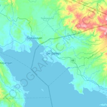
Name: Del Gallego topographic map, elevation, terrain.
Location: Del Gallego, Camarines Sur, Bicol Region, 4411, Philippines (13.88087 122.55262 14.01292 122.83460)
Average elevation: 99 m
Minimum elevation: -2 m
Maximum elevation: 633 m
Other topographic maps
Click on a map to view its topography, its elevation and its terrain.
Calabanga
The topographic landscape of the municipality could be characterized as generally flat with a slope 0-3%, gently sloping (3-8%) towards the direction of the eastern portion and finally rolling up to higher steeps towards the direction of the south-eastern part going to Mt. Isarog. The 0-3% slope is a broad…
Average elevation: 11 m
Nabua
Nabua has about 8,803.0600 hectares or 99.42% very low elevation or less than 100 meters elevation and remaining 51.3593 hectares or 0.58% of low elevation or between 100 and 300 meters elevation. Its slope covers about 7,927.3616 hectares or 89.53% which are level to nearly level (0-3%) while the remaining…
Average elevation: 27 m
Buhi
Buhi has generally mountainous and hilly surface, with 50% of its area having a slope of around 25%. The Poblacion located on the south shore of Lake Buhi, has gently rolling topography.
Average elevation: 161 m
Mount Isarog
Mount Isarog is an active stratovolcano located in the province of Camarines Sur, Philippines, on the island of Luzon. The mountain has active fumaroles and hot springs. It has an elevation of 2,011.6 m (6,600 ft) above mean sea level.
Average elevation: 1,565 m
Godofredo Reyes Sr. (Catabangan Crossing)
Philippines > Camarines Sur > Godofredo Reyes Sr. (Catabangan Crossing)
Average elevation: 64 m