
Sandhikharka topographic map
Interactive map
Click on the map to display elevation.
About this map
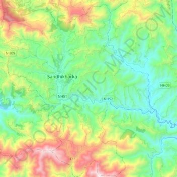
Name: Sandhikharka topographic map, elevation, terrain.
Location: Sandhikharka, Arghakhanchi, 32700, Nepal (27.89039 83.05586 28.04051 83.21672)
Average elevation: 1,245 m
Minimum elevation: 773 m
Maximum elevation: 2,260 m
Other topographic maps
Click on a map to view its topography, its elevation and its terrain.
Thada
Nepal > Arghakhanchi > Thada
Thada, Sitganga, Arghakhanchi, Lumbini Province, Nepal
Average elevation: 953 m
Dharapani
Dharapani, Bhumekasthan, Arghakhanchi, Lumbini Province, Nepal
Average elevation: 1,195 m