
Galu topographic map
Interactive map
Click on the map to display elevation.
About this map
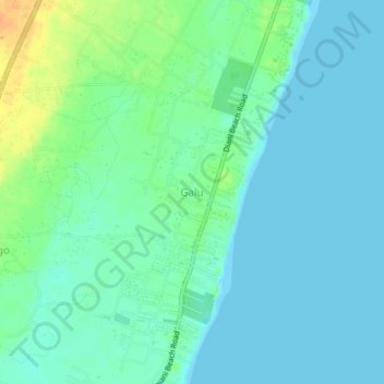
Name: Galu topographic map, elevation, terrain.
Location: Galu, Kwale, Coastal Kenya, 80403, Kenya (-4.37000 39.53909 -4.33000 39.57909)
Average elevation: 9 m
Minimum elevation: 0 m
Maximum elevation: 34 m
Other topographic maps
Click on a map to view its topography, its elevation and its terrain.
Congo river
Congo river, Gombato, Kwale, Coastal Kenya, 40397, Kenya
Average elevation: 30 m
Diani Beach
Diani Beach, Ukunda, Kwale, Coastal Kenya, 80401, Kenya
Average elevation: 9 m
Shimba Hills National Reserve
Shimba Hills National Reserve, Kwale - tiribe road, Jiweni, Kwale, Kenya
Average elevation: 183 m