
Amicalola Falls topographic map
Interactive map
Click on the map to display elevation.
About this map
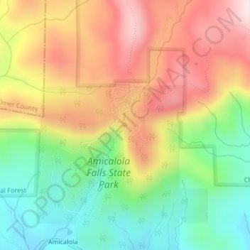
Name: Amicalola Falls topographic map, elevation, terrain.
Location: Amicalola Falls, Dawson County, Georgia, United States (34.56736 -84.24432 34.56746 -84.24422)
Average elevation: 704 m
Minimum elevation: 522 m
Maximum elevation: 903 m
Other topographic maps
Click on a map to view its topography, its elevation and its terrain.
Juno
United States > Georgia > Dawson County
Juno, Dawson County, Georgia, United States
Average elevation: 454 m
Dawsonville
United States > Georgia > Dawson County
Dawsonville, Dawson County, Georgia, United States
Average elevation: 412 m