
Ain Ben Beida topographic map
Interactive map
Click on the map to display elevation.
About this map
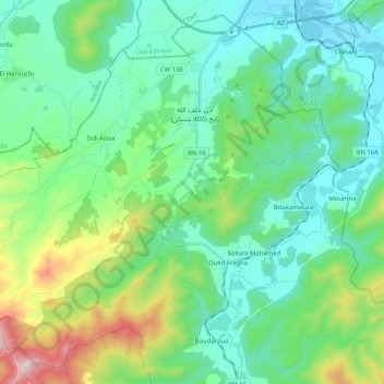
Name: Ain Ben Beida topographic map, elevation, terrain.
Location: Ain Ben Beida, Boucheghouf District, Guelma, 24046, Algeria (36.51085 7.56418 36.66305 7.76985)
Average elevation: 203 m
Minimum elevation: 19 m
Maximum elevation: 827 m
Other topographic maps
Click on a map to view its topography, its elevation and its terrain.
Boucheghouf
Algeria > Guelma > Boucheghouf District > Boucheghouf
Boucheghouf, Boucheghouf District, Guelma, 24200, Algeria
Average elevation: 356 m