
Bindura topographic map
Interactive map
Click on the map to display elevation.
About this map
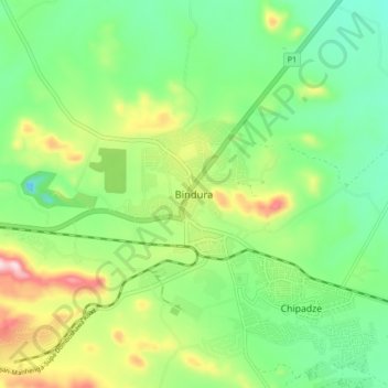
Name: Bindura topographic map, elevation, terrain.
Location: Bindura, Mashonaland Central Province, Zimbabwe (-17.33897 31.28997 -17.25897 31.36997)
Average elevation: 1,089 m
Minimum elevation: 970 m
Maximum elevation: 1,320 m
Other topographic maps
Click on a map to view its topography, its elevation and its terrain.
Breacon Dam
Zimbabwe > Mashonaland Central Province > Bindura > Mazowe
Breacon Dam, Mazowe, Bindura, Mashonaland Central Province, Zimbabwe
Average elevation: 1,254 m
Gena
Zimbabwe > Mashonaland Central Province > Bindura
Gena, Bindura, Mashonaland Central Province, Zimbabwe
Average elevation: 1,327 m