
Bukavu topographic map
Interactive map
Click on the map to display elevation.
About this map
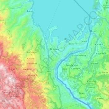
Name: Bukavu topographic map, elevation, terrain.
Location: Bukavu, South Kivu, Democratic Republic of the Congo (-2.56117 28.79369 -2.46016 28.89310)
Average elevation: 1,754 m
Minimum elevation: 1,423 m
Maximum elevation: 2,190 m
Köppen-Geiger climate classification system classifies Bukavu's climate as tropical savanna (Aw), although it is milder than most climates of its type due to high altitude. Bukavu sees very warm days and pleasant nights year round.
Other topographic maps
Click on a map to view its topography, its elevation and its terrain.
Mabe
Democratic Republic of the Congo > South Kivu > Kalehe > Kichanga
Mabe, Kichanga, Buhavu (chefferie), Kalehe, South Kivu, Democratic Republic of the Congo
Average elevation: 1,227 m
Bangwe
Democratic Republic of the Congo > South Kivu > Fizi
Bangwe, Tanganyika, Fizi, South Kivu, Democratic Republic of the Congo
Average elevation: 875 m
Mwenga
Democratic Republic of the Congo > South Kivu
Mwenga, South Kivu, Democratic Republic of the Congo
Average elevation: 1,603 m
Bibogobogo
Democratic Republic of the Congo > South Kivu > Fizi > Bibogobogo
Bibogobogo, Mutambala, Fizi, South Kivu, Democratic Republic of the Congo
Average elevation: 1,638 m
Fizi
Democratic Republic of the Congo > South Kivu > Fizi > Fizi
Fizi, Mutambala, Fizi, South Kivu, Democratic Republic of the Congo
Average elevation: 1,170 m
Kibale
Democratic Republic of the Congo > South Kivu > Idjwi
Kibale, Rubenga (chefferie), Idjwi, South Kivu, Democratic Republic of the Congo
Average elevation: 1,506 m
Bijombo
Democratic Republic of the Congo > South Kivu > Bijombo
Bijombo, Itombwe (secteur), Mwenga, South Kivu, Democratic Republic of the Congo
Average elevation: 1,888 m
South Kivu
Democratic Republic of the Congo > South Kivu
South Kivu, Democratic Republic of the Congo
Average elevation: 1,029 m
Mikenge
Democratic Republic of the Congo > South Kivu > Mikenge
Mikenge, Itombwe (secteur), Mwenga, South Kivu, Democratic Republic of the Congo
Average elevation: 1,327 m
Kipupu
Democratic Republic of the Congo > South Kivu > Kipupu
Kipupu, Itombwe (secteur), Mwenga, South Kivu, Democratic Republic of the Congo
Average elevation: 1,637 m
Uvira
Democratic Republic of the Congo > South Kivu > Uvira
Uvira, South Kivu, Democratic Republic of the Congo
Average elevation: 1,744 m