
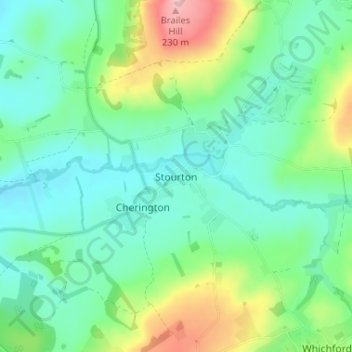
Stourton topographic map
Interactive map
Click on the map to display elevation.
About this map
Name: Stourton topographic map, elevation, terrain.
Average elevation: 120 m
Minimum elevation: 77 m
Maximum elevation: 237 m
Other topographic maps
Click on a map to view its topography, its elevation and its terrain.
Compton Verney CP
United Kingdom > England > Warwickshire > Stratford-on-Avon
Average elevation: 103 m
Sutton-under-Brailes
United Kingdom > England > Warwickshire > Stratford-on-Avon > Stourton
Average elevation: 125 m
Burton Dassett CP
United Kingdom > England > Warwickshire > Stratford-on-Avon
Average elevation: 119 m
Barcheston
United Kingdom > England > Warwickshire > Stratford-on-Avon > Willington
Average elevation: 82 m
Edgehill
United Kingdom > England > Warwickshire > Stratford-on-Avon > Radway
Average elevation: 157 m
Stratford-on-Avon
United Kingdom > England > Warwickshire > Stratford-on-Avon
Average elevation: 108 m
Oversley Wood
United Kingdom > England > Warwickshire > Stratford-on-Avon > Alcester > Exhall
Average elevation: 64 m
Cranhill
United Kingdom > England > Warwickshire > Stratford-on-Avon > Ardens Grafton
Average elevation: 57 m
Burton Dassett Hills Country Park
United Kingdom > England > Warwickshire > Stratford-on-Avon > Northend > Burton Dassett CP
Average elevation: 132 m
Stratford-upon-Avon
United Kingdom > England > Warwickshire > Stratford-on-Avon
Average elevation: 61 m
Barton-on-the-Heath
United Kingdom > England > Warwickshire > Stratford-on-Avon
Average elevation: 130 m
Welford on Avon CP
United Kingdom > England > Warwickshire > Stratford-on-Avon
Average elevation: 44 m
Priors Hardwick CP
United Kingdom > England > Warwickshire > Stratford-on-Avon
Average elevation: 134 m
Stretton-on-Fosse
United Kingdom > England > Warwickshire > Stratford-on-Avon
Average elevation: 108 m
Lye Green
United Kingdom > England > Warwickshire > Stratford-on-Avon > Claverdon > Lye Green
Average elevation: 106 m
Upper Quinton
United Kingdom > England > Warwickshire > Stratford-on-Avon > Lower Quinton > Upper Quinton
Average elevation: 70 m
Winderton
United Kingdom > England > Warwickshire > Stratford-on-Avon > Winderton
Average elevation: 151 m
Bishop's Itchington
United Kingdom > England > Warwickshire > Stratford-on-Avon > Bishop's Itchington
Average elevation: 105 m
Meon Vale
United Kingdom > England > Warwickshire > Stratford-on-Avon > Meon Vale
Average elevation: 61 m
Ladbroke (Millennium Green)
United Kingdom > England > Warwickshire > Stratford-on-Avon > Ladbroke CP
Average elevation: 98 m
Bishops Itchington
United Kingdom > England > Warwickshire > Stratford-on-Avon
Average elevation: 104 m
Tanworth in Arden CP
United Kingdom > England > Warwickshire > Stratford-on-Avon
Average elevation: 139 m
Brailes
United Kingdom > England > Warwickshire > Stratford-on-Avon > Lower Brailes
Average elevation: 139 m
Napton on the Hill
United Kingdom > England > Warwickshire > Stratford-on-Avon
Average elevation: 113 m
Lower Binton
United Kingdom > England > Warwickshire > Stratford-on-Avon > Binton
Average elevation: 52 m
Pathlow
United Kingdom > England > Warwickshire > Stratford-on-Avon > Wilmcote CP
Average elevation: 84 m
Pillerton Hersey
United Kingdom > England > Warwickshire > Stratford-on-Avon > Pillerton Hersey
Average elevation: 92 m
Tredington
United Kingdom > England > Warwickshire > Stratford-on-Avon > Tredington
Average elevation: 73 m
Lower Tysoe
United Kingdom > England > Warwickshire > Stratford-on-Avon > Middle Tysoe
Average elevation: 127 m
Bidford on Avon CP
United Kingdom > England > Warwickshire > Stratford-on-Avon
Average elevation: 42 m
Marlcliff
United Kingdom > England > Warwickshire > Stratford-on-Avon > Bidford on Avon CP
Average elevation: 40 m
Goldicote
United Kingdom > England > Warwickshire > Stratford-on-Avon > Alderminster CP
Average elevation: 73 m