
Make a donation
Gear up for your next adventure:
As an Amazon Associate, this site earns from qualifying purchases at no extra cost to you.
Mt. Hayachine topographic map
Click on the map to display elevation.
Make a donation
Gear up for your next adventure:
As an Amazon Associate, this site earns from qualifying purchases at no extra cost to you.
Mt. Hayachine
Mount Hayachine (早池峰山, Hayachine-san) is the highest mountain in the Kitakami Range, located in the Tōhoku region of northern Honshū, Japan. With an elevation of 1,917 m (6,289 ft), it is the second highest in Iwate Prefecture after Mount Iwate. Mount Hayachine is mentioned in 100 Famous Japanese Mountains, a book written in 1964 by Kyūya Fukada. The mountain is on the borders of the municipalities of Hanamaki, Tōno, and Miyako, east of the prefectural capital of Morioka.
Make a donation
Gear up for your next adventure:
As an Amazon Associate, this site earns from qualifying purchases at no extra cost to you.
About this map
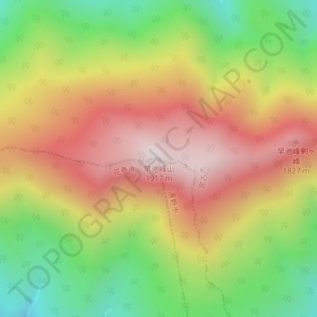
Name: Mt. Hayachine topographic map, elevation, terrain.
Location: Mt. Hayachine, Miyako, Iwate Prefecture, Japan (39.55832 141.48897 39.55842 141.48907)
Average elevation: 1,490 m
Minimum elevation: 1,062 m
Maximum elevation: 1,904 m
Make a donation
Gear up for your next adventure:
As an Amazon Associate, this site earns from qualifying purchases at no extra cost to you.