
Madison topographic map
Click on the map to display elevation.
Madison
The city is sometimes described as The City of Four Lakes, comprising the four successive lakes of the Yahara River: Lake Mendota ("Fourth Lake"), Lake Monona ("Third Lake"), Lake Waubesa ("Second Lake") and Lake Kegonsa ("First Lake"), although Waubesa and Kegonsa are not actually in Madison, but just south of it. A fifth smaller lake, Lake Wingra, is within the city as well; it is connected to the Yahara River chain by Wingra Creek. The Yahara flows into the Rock River, which flows into the Mississippi River. Downtown Madison is located on an isthmus between Lakes Mendota and Monona. The city's trademark of "Lake, City, Lake" reflects this geography. The city's lowest elevation is Lake Monona, at 845 ft (258 m). The highest elevation is located along S. Pleasant View Rd. on the far west side of the city, atop a portion of a terminal moraine of the Green Bay Lobe of the Wisconsin Glaciation, at 1,192 ft (363 m).
About this map
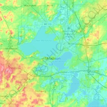
Name: Madison topographic map, elevation, terrain.
Location: Madison, Dane County, Wisconsin, United States (42.99815 -89.57166 43.17192 -89.23208)
Average elevation: 284 m
Minimum elevation: 256 m
Maximum elevation: 369 m
Other topographic maps
Click on a map to view its topography, its elevation and its terrain.
Walking Iron County Park
United States > Wisconsin > Dane County > Town of Mazomanie
Average elevation: 236 m
Isthmus Path Prairie Garden
United States > Wisconsin > Dane County > Madison
Average elevation: 262 m
Deansville Wildlife Area
United States > Wisconsin > Dane County > Town of York
Average elevation: 264 m