
Make a donation
Gear up for your next adventure:
As an Amazon Associate, this site earns from qualifying purchases at no extra cost to you.
Hawling topographic map
Click on the map to display elevation.
Make a donation
Gear up for your next adventure:
As an Amazon Associate, this site earns from qualifying purchases at no extra cost to you.
About this map
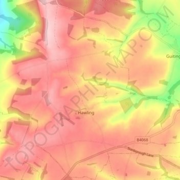
Name: Hawling topographic map, elevation, terrain.
Location: Hawling, Tewkesbury, Gloucestershire, England, United Kingdom (51.88700 -1.92993 51.93578 -1.85362)
Average elevation: 241 m
Minimum elevation: 122 m
Maximum elevation: 300 m
Gloucestershire trails, hiking, mountain biking, running and outdoor activities
Make a donation
Gear up for your next adventure:
As an Amazon Associate, this site earns from qualifying purchases at no extra cost to you.
Other topographic maps
Click on a map to view its topography, its elevation and its terrain.
Make a donation
Gear up for your next adventure:
As an Amazon Associate, this site earns from qualifying purchases at no extra cost to you.
Bamfurlong
United Kingdom > England > Gloucestershire > Tewkesbury > Staverton
Average elevation: 34 m
Make a donation
Gear up for your next adventure:
As an Amazon Associate, this site earns from qualifying purchases at no extra cost to you.
Make a donation
Gear up for your next adventure:
As an Amazon Associate, this site earns from qualifying purchases at no extra cost to you.
Little Shurdington
United Kingdom > England > Gloucestershire > Tewkesbury > Bentham
Average elevation: 112 m
Make a donation
Gear up for your next adventure:
As an Amazon Associate, this site earns from qualifying purchases at no extra cost to you.
Lower Apperley
United Kingdom > England > Gloucestershire > Tewkesbury > Apperley
Average elevation: 16 m
Alney Island
United Kingdom > England > Gloucestershire > Tewkesbury > Maisemore
Average elevation: 13 m
Make a donation
Gear up for your next adventure:
As an Amazon Associate, this site earns from qualifying purchases at no extra cost to you.
Bishop's Cleeve
United Kingdom > England > Gloucestershire > Tewkesbury > Gotherington
Average elevation: 51 m
Make a donation
Gear up for your next adventure:
As an Amazon Associate, this site earns from qualifying purchases at no extra cost to you.
Make a donation
Gear up for your next adventure:
As an Amazon Associate, this site earns from qualifying purchases at no extra cost to you.
Wood Stanway
United Kingdom > England > Gloucestershire > Tewkesbury > Stanway
Average elevation: 171 m