
Beeston topographic map
Click on the map to display elevation.
About this map
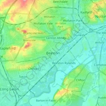
Name: Beeston topographic map, elevation, terrain.
Average elevation: 44 m
Minimum elevation: 20 m
Maximum elevation: 122 m
Nottinghamshire trails, hiking, mountain biking, running and outdoor activities
Other topographic maps
Click on a map to view its topography, its elevation and its terrain.
Manor House Pond
United Kingdom > England > Nottinghamshire > Broxtowe > Bramcote
Average elevation: 57 m
River Erewash
United Kingdom > England > Nottinghamshire > Broxtowe
The approximate meaning of the name is not in doubt, but there is room for debate about the precise derivation and its connotations. Brewer gives the commonly accepted explanation that it comes from the Old English words irre ("wandering") and wisce ("wet meadow"). This is accepted by Kenneth Cameron, a…
Average elevation: 87 m
Nottingham Canal Local Nature Reserve
United Kingdom > England > Nottinghamshire > Broxtowe
Average elevation: 66 m
Attenborough Nature Reserve
United Kingdom > England > Nottinghamshire > Broxtowe > Beeston
Average elevation: 34 m