Geolocate

Locust Grove topographic map

Click on the map to display elevation.

About this map

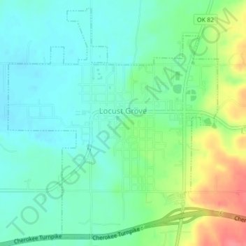
Name: Locust Grove topographic map, elevation, terrain.

Location: Locust Grove, Mayes County, Oklahoma, 74352, United States (36.18553 -95.18407 36.21182 -95.14917)

Average elevation: 213 m

Minimum elevation: 191 m

Maximum elevation: 263 m

Other topographic maps

Click on a map to view its topography, its elevation and its terrain.

Pryor Creek

United States > Oklahoma > Mayes County

Average elevation: 190 m

Lusta

United States > Oklahoma > Mayes County

Average elevation: 190 m

Pryor Creek

United States > Oklahoma > Mayes County

Average elevation: 190 m

Gear up for your next adventure:

🥾Walking Shoes - Lightweight walking shoes for countryside and coastal paths
🧦Hiking Socks - Breathable socks designed to prevent blisters on long walks
📢Survival Whistles - Essential safety gear for signaling for help in mountain fog
🧴Sport Sunscreen Sticks - High-protection sunblock that won't run into your eyes on the trail
📕Outdoor Navigation Books - Learn traditional and modern navigation techniques

As an Amazon Associate, this site earns from qualifying purchases at no extra cost to you.