
Make a donation
Gear up for your next adventure:
As an Amazon Associate, this site earns from qualifying purchases at no extra cost to you.
Great Skellig topographic map
Click on the map to display elevation.
Make a donation
Gear up for your next adventure:
As an Amazon Associate, this site earns from qualifying purchases at no extra cost to you.
Great Skellig
Skellig Michael consists of approximately 22 hectares (54 acres) of rock, with its highest point, known as the Spit, 218 m (714 ft) above sea level. The island is defined by its twin peaks and intervening valley (known as Christ's Saddle), which make its landscape steep and inhospitable. It is best known for its Gaelic monastery, founded between the 6th and 8th centuries, and its variety of inhabiting species, which include gannets, puffins, a colony of razorbills and a population of approximately fifty grey seals. The island is of special interest to archaeologists, as the monastic settlement is in unusually good condition. The rock contains the remains of a tower house, a megalithic stone row and a cross-inscribed slab known as the Wailing Woman. The monastery is situated at an elevation of 170 to 180 m (550 to 600 ft), Christ's Saddle at 129 m (422 ft), and the flagstaff area at 37 m (120 ft) above sea level.
Make a donation
Gear up for your next adventure:
As an Amazon Associate, this site earns from qualifying purchases at no extra cost to you.
About this map
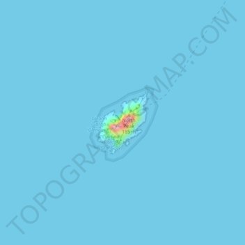
Name: Great Skellig topographic map, elevation, terrain.
Average elevation: 1 m
Minimum elevation: 0 m
Maximum elevation: 161 m
Make a donation
Gear up for your next adventure:
As an Amazon Associate, this site earns from qualifying purchases at no extra cost to you.
Other topographic maps
Click on a map to view its topography, its elevation and its terrain.
Carrauntoohil
Carrauntoohil is the highest mountain in Ireland on all classification scales. It is the 133rd-highest mountain, and 4th most prominent mountain, in Britain and Ireland, on the Simms classification. Carrauntoohil is regarded by the Scottish Mountaineering Club (SMC) as one of 34 Furths, which are defined as…
Average elevation: 644 m
Make a donation
Gear up for your next adventure:
As an Amazon Associate, this site earns from qualifying purchases at no extra cost to you.
Make a donation
Gear up for your next adventure:
As an Amazon Associate, this site earns from qualifying purchases at no extra cost to you.
Make a donation
Gear up for your next adventure:
As an Amazon Associate, this site earns from qualifying purchases at no extra cost to you.
Make a donation
Gear up for your next adventure:
As an Amazon Associate, this site earns from qualifying purchases at no extra cost to you.
Make a donation
Gear up for your next adventure:
As an Amazon Associate, this site earns from qualifying purchases at no extra cost to you.
Make a donation
Gear up for your next adventure:
As an Amazon Associate, this site earns from qualifying purchases at no extra cost to you.
Make a donation
Gear up for your next adventure:
As an Amazon Associate, this site earns from qualifying purchases at no extra cost to you.
Make a donation
Gear up for your next adventure:
As an Amazon Associate, this site earns from qualifying purchases at no extra cost to you.
Make a donation
Gear up for your next adventure:
As an Amazon Associate, this site earns from qualifying purchases at no extra cost to you.
Make a donation
Gear up for your next adventure:
As an Amazon Associate, this site earns from qualifying purchases at no extra cost to you.
Dingle
Dingle's St. Mary's is a neo-Gothic church built to designs by J. J. McCarthy and O'Connell. The foundation stone was laid in 1862. It originally had a nave and aisles separated by arcades, supported on columns capped by octagonal tops. The arcades were demolished in one of the most radical reordering schemes…
Average elevation: 41 m
Make a donation
Gear up for your next adventure:
As an Amazon Associate, this site earns from qualifying purchases at no extra cost to you.
Make a donation
Gear up for your next adventure:
As an Amazon Associate, this site earns from qualifying purchases at no extra cost to you.
Make a donation
Gear up for your next adventure:
As an Amazon Associate, this site earns from qualifying purchases at no extra cost to you.
Make a donation
Gear up for your next adventure:
As an Amazon Associate, this site earns from qualifying purchases at no extra cost to you.
Make a donation
Gear up for your next adventure:
As an Amazon Associate, this site earns from qualifying purchases at no extra cost to you.
Make a donation
Gear up for your next adventure:
As an Amazon Associate, this site earns from qualifying purchases at no extra cost to you.
Make a donation
Gear up for your next adventure:
As an Amazon Associate, this site earns from qualifying purchases at no extra cost to you.
Make a donation
Gear up for your next adventure:
As an Amazon Associate, this site earns from qualifying purchases at no extra cost to you.
Make a donation
Gear up for your next adventure:
As an Amazon Associate, this site earns from qualifying purchases at no extra cost to you.
Beenkeragh
Beenkeragh is the second-highest peak in Ireland, on both the Arderin and Vandeleur-Lynam lists. It is the 179th-highest mountain in Britain and Ireland on the Simm classification. Beenkeragh is regarded by the Scottish Mountaineering Club ("SMC") as one of 34 Furths, which is a mountain above 3,000 ft (914 m)…
Average elevation: 654 m
Make a donation
Gear up for your next adventure:
As an Amazon Associate, this site earns from qualifying purchases at no extra cost to you.
Caher
Caher is the 200th–highest mountain in Britain and Ireland on the Simm classification. Caher is regarded by the Scottish Mountaineering Club ("SMC") as one of 34 Furths, which is a mountain above 3,000 ft (914.4 m) in elevation, and meets the other SMC criteria for a Munro (e.g. "sufficient separation"), but…
Average elevation: 617 m
Knocknapeasta
It is the 231st-highest mountain in Britain and Ireland on the Simm classification. Cnoc na Péiste is regarded by the Scottish Mountaineering Club ("SMC") as one of 34 Furths, which is a mountain above 3,000 ft (914.4 m) in elevation, and meets the other SMC criteria for a Munro (e.g. "sufficient…
Average elevation: 579 m
Make a donation
Gear up for your next adventure:
As an Amazon Associate, this site earns from qualifying purchases at no extra cost to you.
Make a donation
Gear up for your next adventure:
As an Amazon Associate, this site earns from qualifying purchases at no extra cost to you.
Killarney National Park
Killarney National Park is in southwest Ireland close to the island's most westerly point. The Lakes of Killarney and the Mangerton, Torc, Shehy and Purple Mountains are in the park. Altitudes in the park range from 22 metres (72 ft) to 842 metres (2,762 ft). A major geological boundary between Devonian Old…
Average elevation: 212 m
Make a donation
Gear up for your next adventure:
As an Amazon Associate, this site earns from qualifying purchases at no extra cost to you.
Make a donation
Gear up for your next adventure:
As an Amazon Associate, this site earns from qualifying purchases at no extra cost to you.
Make a donation
Gear up for your next adventure:
As an Amazon Associate, this site earns from qualifying purchases at no extra cost to you.