
吉首市 topographic map
Interactive map
Click on the map to display elevation.
About this map
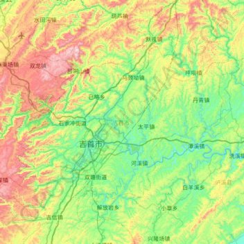
Name: 吉首市 topographic map, elevation, terrain.
Location: 吉首市, 湘西土家族苗族自治州, 湖南省, 中国 (28.14479 109.46750 28.47631 110.06018)
Average elevation: 447 m
Minimum elevation: 119 m
Maximum elevation: 1,170 m
Other topographic maps
Click on a map to view its topography, its elevation and its terrain.
湘潭市雨湖区渡佳坝工程管理所
湘潭市雨湖区渡佳坝工程管理所, 烧汤河, 响塘乡, 雨湖区, 湘潭市, 湖南省, 中国
Average elevation: 47 m