
Bhairamgarh Tahsil topographic map
Interactive map
Click on the map to display elevation.
About this map
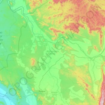
Name: Bhairamgarh Tahsil topographic map, elevation, terrain.
Location: Bhairamgarh Tahsil, Bijapur District, Chhattisgarh, India (18.72952 80.52472 19.34636 81.23068)
Average elevation: 386 m
Minimum elevation: 118 m
Maximum elevation: 1,229 m
Other topographic maps
Click on a map to view its topography, its elevation and its terrain.
Indravati National Park
India > Chhattisgarh > Bijapur District
The topography of the park mainly comprises undulating hilly terrain with altitude ranging between 177 and 599 metres above the sea level.
Average elevation: 253 m