Geolocate

Rhewl-Mostyn topographic map

Interactive map

Click on the map to display elevation.

About this map

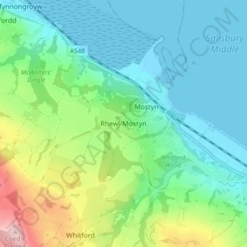
Name: Rhewl-Mostyn topographic map, elevation, terrain.

Location: Rhewl-Mostyn, Flintshire, Wales, CH8 9QL, United Kingdom (53.29197 -3.29197 53.33197 -3.25197)

Average elevation: 63 m

Minimum elevation: -2 m

Maximum elevation: 245 m

Flintshire trails, hiking, mountain biking, running and outdoor activities

Other topographic maps

Click on a map to view its topography, its elevation and its terrain.

Saltney

United Kingdom > Wales > Flintshire

Average elevation: 9 m

Wepre Park

United Kingdom > Wales > Flintshire > Connah's Quay

Average elevation: 46 m

Penyffordd

United Kingdom > Wales > Flintshire

Average elevation: 101 m

Bagilt Reservior

United Kingdom > Wales > Flintshire > Bagillt

Average elevation: 32 m

Nannerch

United Kingdom > Wales > Flintshire > Nannerch

Average elevation: 232 m

Ewloe Castle

United Kingdom > Wales > Flintshire > Ewloe

Average elevation: 74 m