
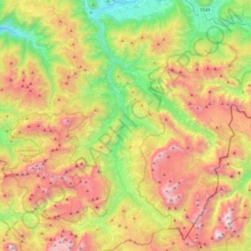
Gadertal - Val Badia topographic map
Interactive map
Click on the map to display elevation.
About this map
Name: Gadertal - Val Badia topographic map, elevation, terrain.
Average elevation: 1,853 m
Minimum elevation: 802 m
Maximum elevation: 3,206 m
Other topographic maps
Click on a map to view its topography, its elevation and its terrain.
Welsberg - Monguelfo
Italy > Trentino – Alto Adige/Südtirol > South Tyrol > Welsberg-Taisten - Monguelfo-Tesido
Average elevation: 1,289 m
Bolzano - Bozen
Italy > Trentino – Alto Adige/Südtirol > South Tyrol
The area of the city of Bolzano is 52.3 km2 (20 sq. mi.), of which 28 km2 (10 sq. mi.) is used as a settlement area. The city is located in the basin where the Sarntal, Eisacktal, and the Adige Valley with their rivers, Talfer, Eisack, and Adige, meet. In the Middle Ages, the two main Alpine crossings, the Via…
Average elevation: 716 m
Villa Nöia
Italy > Trentino – Alto Adige/Südtirol > South Tyrol > La Ila - Stern - La Villa
Average elevation: 1,632 m
Costadedoi
Italy > Trentino – Alto Adige/Südtirol > South Tyrol > San Ćiascian - St. Kassian - San Cassiano
Average elevation: 1,712 m
Roen
Italy > Trentino – Alto Adige/Südtirol > South Tyrol > Tramin an der Weinstraße - Termeno sulla Strada del Vino
Average elevation: 1,740 m
Maring
Italy > Trentino – Alto Adige/Südtirol > South Tyrol > La Ila - Stern - La Villa
Average elevation: 1,727 m
Funtanacia
Italy > Trentino – Alto Adige/Südtirol > South Tyrol > La Ila - Stern - La Villa
Average elevation: 1,787 m
Schneespitz - Cima della Neve
Italy > Trentino – Alto Adige/Südtirol > South Tyrol > Predoi
Average elevation: 2,497 m
Neumarkt - Egna
Italy > Trentino – Alto Adige/Südtirol > South Tyrol
The town is situated on the plain, elevation 214 metres (702 ft), on the left side of the Adige river.
Average elevation: 760 m
Urtijëi - St. Ulrich in Gröden - Ortisei
Italy > Trentino – Alto Adige/Südtirol > South Tyrol
Average elevation: 1,689 m
Pinzon - Pinzano
Italy > Trentino – Alto Adige/Südtirol > South Tyrol > Montan an der Weinstraße - Montagna sulla Strada del Vino
Average elevation: 524 m
Grube - Fossa
Italy > Trentino – Alto Adige/Südtirol > South Tyrol > Oberradein - Redagno di Sopra
Average elevation: 1,477 m
Atzwang - Campodazzo
Italy > Trentino – Alto Adige/Südtirol > South Tyrol > Ritten - Renon
Average elevation: 786 m
Rasen-Antholz - Rasun-Anterselva
Italy > Trentino – Alto Adige/Südtirol > South Tyrol
Rasen-Antholz is known for the South Tyrol Arena biathlon track, which opened in 1971. It hosted the Biathlon World Championships in 1975, 1976, 1983, 1995, 2007 and 2020. It is also a regular venue of the Biathlon World Cup season, with the highest altitude of all World Cup meetings at a height of about 1,600…
Average elevation: 1,934 m
La Val - Wengen - La Valle
Italy > Trentino – Alto Adige/Südtirol > South Tyrol
Average elevation: 1,669 m
St. Anton - Sant'Antonio
Italy > Trentino – Alto Adige/Südtirol > South Tyrol > St. Nikolaus - San Nicolò
Average elevation: 745 m
Ortler - Ortles
Italy > Trentino – Alto Adige/Südtirol > South Tyrol > Stilfs - Stelvio
The Ortler was first climbed by Josef Pichler [de] ("Pseirer-Josele"), a chamois hunter from St. Leonhard in Passeier, and his companions Johann Leitner and Johann Klausner from Zell am Ziller on 27 September 1804. The ascent had been a request of Archduke Johann of Austria, who felt strongly that after the…
Average elevation: 3,175 m
Sulden - Solda
Italy > Trentino – Alto Adige/Südtirol > South Tyrol > Stilfs - Stelvio
Average elevation: 2,232 m
Sarns - Sarnes
Italy > Trentino – Alto Adige/Südtirol > South Tyrol > Brixen - Bressanone
Average elevation: 726 m
St. Georg - San Giorgio di Eores
Italy > Trentino – Alto Adige/Südtirol > South Tyrol > Brixen - Bressanone
Average elevation: 1,476 m
Turnerkamp - Cima di Campo
Italy > Trentino – Alto Adige/Südtirol > South Tyrol > Mühlwald - Selva dei Molini
Average elevation: 2,868 m
St. Anton - Sant'Antonio
Italy > Trentino – Alto Adige/Südtirol > South Tyrol > St. Nikolaus - San Nicolò
Average elevation: 745 m
Hoher Weißzint - Punta Bianca
Italy > Trentino – Alto Adige/Südtirol > South Tyrol > Mühlwald - Selva dei Molini
Average elevation: 2,905 m
Jenesien - San Genesio Atesino
Italy > Trentino – Alto Adige/Südtirol > South Tyrol
Average elevation: 1,136 m
Antermëia - Untermoi - Antermoia
Italy > Trentino – Alto Adige/Südtirol > South Tyrol > San Martin de Tor - San Martino in Badia - St. Martin in Thurn
Average elevation: 1,677 m
San Martin de Tor - San Martino in Badia - St. Martin in Thurn
Italy > Trentino – Alto Adige/Südtirol > South Tyrol
Average elevation: 1,837 m
Corvara in Badia - Corvara
Italy > Trentino – Alto Adige/Südtirol > South Tyrol
Average elevation: 2,037 m
Schluderbach - Carbonin
Italy > Trentino – Alto Adige/Südtirol > South Tyrol > Toblach - Dobbiaco
Average elevation: 1,776 m
Lengmoos - Longomoso
Italy > Trentino – Alto Adige/Südtirol > South Tyrol > Ritten - Renon > Klobenstein - Collalbo
Average elevation: 1,049 m
Mühlbach - Rio di Pusteria
Italy > Trentino – Alto Adige/Südtirol > South Tyrol
Average elevation: 1,737 m
Meran - Merano
Italy > Trentino – Alto Adige/Südtirol > South Tyrol
The average daily temperatures in summer in Merano lie between 27 and 30 °C, while at night temperatures usually drop to between 12 and 15 °C. The average daily temperatures in winter lie between 6 and 10 °C, while at night temperatures usually drop to between -4 and -2 °C. The wettest month is August with…
Average elevation: 635 m
Ritten - Renon
Italy > Trentino – Alto Adige/Südtirol > South Tyrol
The 111-square-kilometre (43 sq mi) community is named after the high plateau, elevation 1,100 to 1,400 metres (3,600 to 4,600 ft), the Ritten or the Renon, on which most of the villages are located. The plateau forms the southeast tip of the Sarntal Alps mountain range and is located between, and on average…
Average elevation: 1,123 m
Corvara in Badia - Corvara
Italy > Trentino – Alto Adige/Südtirol > South Tyrol
Average elevation: 2,037 m
Siebeneich - Settequerce
Italy > Trentino – Alto Adige/Südtirol > South Tyrol
Average elevation: 427 m
Salorno sulla Strada del Vino - Salurn an der Weinstraße
Italy > Trentino – Alto Adige/Südtirol > South Tyrol
Average elevation: 774 m
Bolzano - Bozen
Italy > Trentino – Alto Adige/Südtirol > South Tyrol
The area of the city of Bolzano is 52.3 km2 (20.2 sq mi), of which 28 km2 (11 sq mi) is used as a settlement area. The city is located in the basin where the Sarntal, Eisacktal, and the Adige Valley with their rivers, Talfer, Eisack, and Adige, meet. In the Middle Ages, the two main Alpine crossings, the Via…
Average elevation: 716 m
Ahrntal - Valle Aurina
Italy > Trentino – Alto Adige/Südtirol > South Tyrol
Weißenbach is composed of picturesque Alpine farmhouses, grouped around the foaming white glacial stream from which its name is derived. With a population of around 550, it has an elevation of 1,350 metres (4,430 ft) above sea level.
Average elevation: 2,079 m
Obermais - Maia Alta
Italy > Trentino – Alto Adige/Südtirol > South Tyrol > Meran - Merano
Average elevation: 483 m
Dörfl
Italy > Trentino – Alto Adige/Südtirol > South Tyrol > Gsies - Valle di Casies > St. Magdalena - Santa Maddalena in Casies
Average elevation: 1,770 m
Kastelruth - Castelrotto
Italy > Trentino – Alto Adige/Südtirol > South Tyrol
Average elevation: 1,561 m
Sulden - Solda
Italy > Trentino – Alto Adige/Südtirol > South Tyrol > Stilfs - Stelvio
Average elevation: 2,232 m
Pragser Wildsee - Lago di Braies
Italy > Trentino – Alto Adige/Südtirol > South Tyrol > Prags - Braies
Average elevation: 1,744 m
Weissenbach - Rio Bianco
Italy > Trentino – Alto Adige/Südtirol > South Tyrol > Sarntal - Sarentino
Average elevation: 1,718 m
Sëlva - Wolkenstein - Selva di Val Gardena
Italy > Trentino – Alto Adige/Südtirol > South Tyrol
Sëlva is characterized by a typical Alpine climate. Summers are rather short and relatively wet. The average daily temperatures in summer lie between 18 and 21 °C, while at night temperatures usually drop to between 6 and 9 °C. Winters are typically cold, long and relatively dry. The average daily…
Average elevation: 2,146 m
Saslonch - Langkofel - Sassolungo
Italy > Trentino – Alto Adige/Südtirol > South Tyrol > Sëlva - Wolkenstein - Selva di Val Gardena
Average elevation: 2,320 m
Innichen - San Candido
Italy > Trentino – Alto Adige/Südtirol > South Tyrol
Average elevation: 1,791 m
Calfosch - Kolfuschg - Colfosco
Italy > Trentino – Alto Adige/Südtirol > South Tyrol
Average elevation: 1,931 m
Kastelruth - Castelrotto
Italy > Trentino – Alto Adige/Südtirol > South Tyrol
Average elevation: 1,561 m
Meran - Merano
Italy > Trentino – Alto Adige/Südtirol > South Tyrol
The average daily temperatures in summer in Merano lie between 27 and 30 °C, while at night temperatures usually drop to between 12 and 15 °C. The average daily temperatures in winter lie between 6 and 10 °C, while at night temperatures usually drop to between -4 and -2 °C. The wettest month is August with…
Average elevation: 635 m
Urtijëi - St. Ulrich in Gröden - Ortisei
Italy > Trentino – Alto Adige/Südtirol > South Tyrol
Average elevation: 1,689 m
Urtijëi - St. Ulrich in Gröden - Ortisei
Italy > Trentino – Alto Adige/Südtirol > South Tyrol
Average elevation: 1,689 m