Geolocate

Whiteland topographic map

Click on the map to display elevation.

About this map

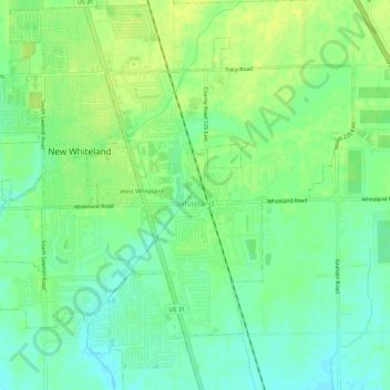
Name: Whiteland topographic map, elevation, terrain.

Location: Whiteland, Johnson County, Indiana, 46184, United States (39.53335 -86.11325 39.56850 -86.05697)

Average elevation: 244 m

Minimum elevation: 235 m

Maximum elevation: 252 m

Other topographic maps

Click on a map to view its topography, its elevation and its terrain.

Samaria

United States > Indiana > Johnson County

Average elevation: 243 m

Samaria

United States > Indiana > Johnson County

Average elevation: 243 m

Amity

United States > Indiana > Johnson County

Average elevation: 214 m

Samaria

United States > Indiana > Johnson County

Average elevation: 243 m

Banta

United States > Indiana > Johnson County > Bargersville

Average elevation: 232 m

Gear up for your next adventure:

👖Packable Overtrousers - Quick-deploy rain protection for legs in sudden storms
🥾Women's Waterproof Hiking Boots - High-performance trekking boots designed for all-weather comfort
🦟Anti-Midge & Tick Repellent - Vital for hiking in the Scottish Highlands during summer
❄️Walking Crampons - Added traction for icy slopes and winter peak bagging
🥾Hiking Boots - Waterproof and durable boots for long-distance hiking in the UK

As an Amazon Associate, this site earns from qualifying purchases at no extra cost to you.