
Make a donation
Gear up for your next adventure:
As an Amazon Associate, this site earns from qualifying purchases at no extra cost to you.
Tututepec topographic map
Click on the map to display elevation.
Make a donation
Gear up for your next adventure:
As an Amazon Associate, this site earns from qualifying purchases at no extra cost to you.
About this map
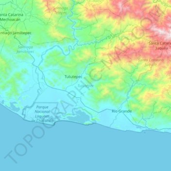
Name: Tututepec topographic map, elevation, terrain.
Location: Tututepec, Oaxaca, 71838, Mexico (15.92292 -97.79160 16.27401 -97.17897)
Average elevation: 351 m
Minimum elevation: -1 m
Maximum elevation: 2,395 m
Make a donation
Gear up for your next adventure:
As an Amazon Associate, this site earns from qualifying purchases at no extra cost to you.
Other topographic maps
Click on a map to view its topography, its elevation and its terrain.
Oaxaca City
Mexico > Oaxaca > Oaxaca de Juárez
Oaxaca has a tropical savanna climate (Köppen climate classification Aw), closely bordering on a humid subtropical climate (Cwa), due to its high altitude. During the dry season, temperatures during the day remain warm with an average high of 27.1 °C (80.8 °F) in the coolest month, December, and an average…
Average elevation: 1,838 m
Colonia el Pajarito
Mexico > Oaxaca > Zimatlán de Álvarez > Zimatlán de Álvarez
Average elevation: 1,519 m
Make a donation
Gear up for your next adventure:
As an Amazon Associate, this site earns from qualifying purchases at no extra cost to you.
Oaxaca City
Mexico > Oaxaca > Oaxaca de Juárez
To counter this, the village petitioned the Crown for elevation to city status, which would grant it certain rights, privileges, and exceptions. It would also ensure that the settlement remained under the king's direct control, rather than Cortés's. This petition was granted in 1532 by Charles V of Spain.
Average elevation: 1,838 m
Punta Zicatela
Mexico > Oaxaca > Santa María Colotepec > Brisas de Zicatela > Punta de Zicatela
Average elevation: 12 m
Make a donation
Gear up for your next adventure:
As an Amazon Associate, this site earns from qualifying purchases at no extra cost to you.
Make a donation
Gear up for your next adventure:
As an Amazon Associate, this site earns from qualifying purchases at no extra cost to you.
Make a donation
Gear up for your next adventure:
As an Amazon Associate, this site earns from qualifying purchases at no extra cost to you.
Make a donation
Gear up for your next adventure:
As an Amazon Associate, this site earns from qualifying purchases at no extra cost to you.
Make a donation
Gear up for your next adventure:
As an Amazon Associate, this site earns from qualifying purchases at no extra cost to you.
Make a donation
Gear up for your next adventure:
As an Amazon Associate, this site earns from qualifying purchases at no extra cost to you.
Make a donation
Gear up for your next adventure:
As an Amazon Associate, this site earns from qualifying purchases at no extra cost to you.
Make a donation
Gear up for your next adventure:
As an Amazon Associate, this site earns from qualifying purchases at no extra cost to you.
Make a donation
Gear up for your next adventure:
As an Amazon Associate, this site earns from qualifying purchases at no extra cost to you.
Make a donation
Gear up for your next adventure:
As an Amazon Associate, this site earns from qualifying purchases at no extra cost to you.
Tamazulápam
Mexico > Oaxaca > Villa de Tamazulápam del Progreso > Tamazulápam
Average elevation: 2,063 m
Make a donation
Gear up for your next adventure:
As an Amazon Associate, this site earns from qualifying purchases at no extra cost to you.