Geolocate

Chumukedima topographic map

Click on the map to display elevation.

About this map

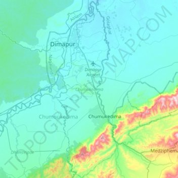
Name: Chumukedima topographic map, elevation, terrain.

Location: Chumukedima, Chumoukedima, Nagaland, India (25.72120 93.70831 25.97365 93.80693)

Average elevation: 221 m

Minimum elevation: 134 m

Maximum elevation: 772 m

Other topographic maps

Click on a map to view its topography, its elevation and its terrain.

Tanhai

India > Nagaland > Mon

Average elevation: 704 m

Chumukedima

India > Nagaland > Chumukedima

Average elevation: 251 m

Chiephobozou

India > Nagaland > Chiephobozou

Average elevation: 1,189 m

Mongsenyimti

India > Nagaland > Chuchuyimlang

Average elevation: 1,005 m

Kohima

India > Nagaland > Kohima Sadar

Kohima district is the land of the Angami Naga and Rengma Naga tribe. It is situated in the foothills of Japfu range located south of Kohima District (25°40′N 94°07′E / 25.67°N 94.12°E / 25.67; 94.12) and has an average elevation of 1,261 metres (4137 feet).

Average elevation: 1,425 m

Dimapur

India > Nagaland > Dimapur Sadar

Average elevation: 204 m

Sechu Zubza

India > Nagaland > Sechu-Zubza > Sechu Zubza

Average elevation: 1,004 m

Kigwema Town

India > Nagaland > Jakhama > Kigwema Town

Average elevation: 1,688 m

Tsuruhu

India > Nagaland > Tsuruhu

Average elevation: 1,978 m

Kohīma

India > Nagaland

Average elevation: 1,001 m

Doyang

India > Nagaland > Sanis > Sanis

Average elevation: 552 m

Doyang HEP Dam

India > Nagaland > Englan

Average elevation: 365 m

Kiphire

India > Nagaland > Kiphire Sadar

Average elevation: 990 m

Phek

India > Nagaland

Average elevation: 1,134 m

Wokha

India > Nagaland

Average elevation: 719 m

Mokokchung

India > Nagaland > ONGPANGKONG (N)

Mokokchung is located at 26°20′N 94°32′E / 26.33°N 94.53°E / 26.33; 94.53. It is located at an elevation of 1325 metres above sea level.

Average elevation: 1,027 m

Gear up for your next adventure:

📸Action Camera Chest Mounts - Record your ascent following topographic paths hands-free
📍Handheld GPS Navigators - Reliable satellite navigation for hiking and off-road exploration
🧴Sport Sunscreen Sticks - High-protection sunblock that won't run into your eyes on the trail
🌂Windproof Trekking Umbrellas - Surprising but effective rain protection on low-wind trails
🖼️Topographic Map Art - Decorative 3D-effect posters of famous UK peaks and regions

As an Amazon Associate, this site earns from qualifying purchases at no extra cost to you.