
Pematang Purba topographic map
Interactive map
Click on the map to display elevation.
About this map
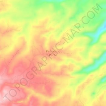
Name: Pematang Purba topographic map, elevation, terrain.
Location: Pematang Purba, Simalungun, North Sumatra, Indonesia (2.91937 98.70596 2.95937 98.74596)
Average elevation: 1,212 m
Minimum elevation: 1,076 m
Maximum elevation: 1,305 m
Other topographic maps
Click on a map to view its topography, its elevation and its terrain.
Kebun Teh Bah Butong
Indonesia > North Sumatra > Simalungun > Sidamanik
Kebun Teh Bah Butong, Sidamanik, Simalungun, North Sumatra, Indonesia
Average elevation: 900 m
Janggir Leto
Indonesia > North Sumatra > Simalungun
Janggir Leto, Simalungun, North Sumatra, Indonesia
Average elevation: 593 m