
Polatlı topographic map
Interactive map
Click on the map to display elevation.
About this map
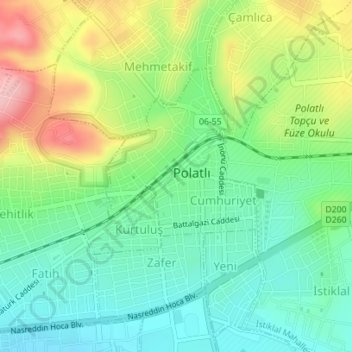
Name: Polatlı topographic map, elevation, terrain.
Average elevation: 889 m
Minimum elevation: 833 m
Maximum elevation: 988 m
Polatlı (formerly Ancient Greek: Γόρδιον, Górdion and Latin: Gordium) is a city and a district in Ankara Province in the Central Anatolia region of Turkey, 80 km west of the Turkish capital Ankara, on the road to Eskişehir. According to 2019 census, population of the district is 125,075 of which 98,605 live in the city of Polatlı. The district covers an area of 3,789 km2, and the average elevation is 850 m.
Other topographic maps
Click on a map to view its topography, its elevation and its terrain.
Karacaahmet
Karacaahmet, Polatlı, Ankara, Central Anatolia Region, Turkey
Average elevation: 683 m
Yassıhüyük
Yassıhüyük, Polatlı, Ankara, Central Anatolia Region, Turkey
Average elevation: 698 m