
James River topographic map
Interactive map
Click on the map to display elevation.
About this map
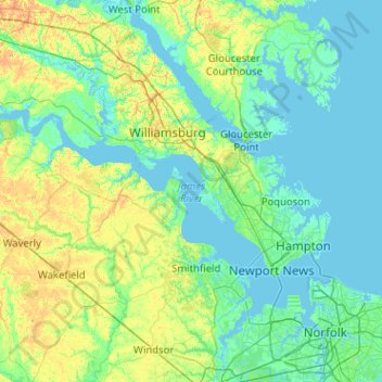
Name: James River topographic map, elevation, terrain.
Location: James River, Isle of Wight County, Virginia, United States (36.89578 -77.31115 37.39491 -76.29441)
Average elevation: 13 m
Minimum elevation: -5 m
Maximum elevation: 74 m
Other topographic maps
Click on a map to view its topography, its elevation and its terrain.
Smithfield
United States > Virginia > Isle of Wight County
Smithfield, Isle of Wight County, Virginia, 23430, United States
Average elevation: 11 m
Carrollton
United States > Virginia > Isle of Wight County
Carrollton, Isle of Wight County, Virginia, 23314, United States
Average elevation: 7 m