
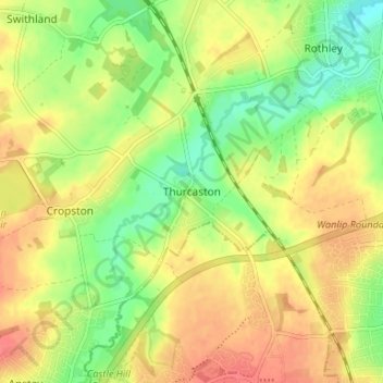
Thurcaston topographic map
Interactive map
Click on the map to display elevation.
About this map
Name: Thurcaston topographic map, elevation, terrain.
Average elevation: 73 m
Minimum elevation: 45 m
Maximum elevation: 97 m
Other topographic maps
Click on a map to view its topography, its elevation and its terrain.
Six Hills
United Kingdom > England > Leicestershire > Charnwood > Burton on the Wolds
Average elevation: 128 m
Old John
United Kingdom > England > Leicestershire > Charnwood > Newtown Linford
Average elevation: 143 m
Watermead Country Park
United Kingdom > England > Leicestershire > Charnwood > Birstall
Average elevation: 59 m
Charnwood Water
United Kingdom > England > Leicestershire > Charnwood > Woodthorpe
Average elevation: 47 m
Lea Wood
United Kingdom > England > Leicestershire > Charnwood > Newtown Linford
Average elevation: 170 m
Moat Hill Spinney
United Kingdom > England > Leicestershire > Charnwood > Cotes
Average elevation: 50 m
Bradgate Park
United Kingdom > England > Leicestershire > Charnwood > Newtown Linford
Overlying the Beacon Hill Formation, but found a little further down the hillside to the south, are the Bradgate Formation beds, the most notable of which is the Sliding Stone Slump Breccia rocks. Forming a line of crags below Old John, these are laminated mudstones, with layers of sandstone, mainly of…
Average elevation: 126 m
Beacon Hill Country Park
United Kingdom > England > Leicestershire > Charnwood > Woodhouse Eaves
Average elevation: 163 m
Top Town Plantation
United Kingdom > England > Leicestershire > Charnwood > Walton on the Wolds
Average elevation: 85 m
Beeby
United Kingdom > England > Leicestershire > Charnwood
The physical and historical development of the hamlet has been strongly influenced by the local topography and its relative isolation. Beeby is situated within an established agricultural landscape largely in pastoral use. Until 1904 the east-west route was the only route through the hamlet, which was referred…
Average elevation: 101 m